

Ready to explore Crowsnest Pass? Here's everything you need to know before you go!
Discover the trail
Trail description
Description
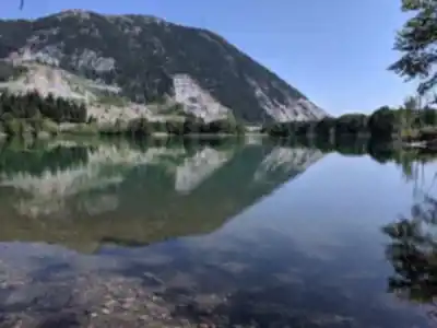
Crowsnest Pass cuts through the Continental Divide in southwestern Alberta, creating a natural corridor between the prairies and the peaks that has drawn travelers for centuries. This mountain pass sits at the intersection of history and wilderness, where coal mining heritage meets some of the most accessible hiking in the Canadian Rockies. The area spans several small communities including Blairmore and Coleman, each serving as gateways to trails that range from family-friendly walks to challenging mountain ascents.
The landscape here tells two stories at once. Above ground, you get classic Rocky Mountain terrain — limestone peaks, alpine meadows, and dense forests of spruce and fir. Below ground lies evidence of the coal seams that built these communities in the early 1900s. That dual character is what makes Crowsnest Pass stand apart from other Rocky Mountain destinations: you're getting both raw natural beauty and a tangible connection to Alberta's industrial past on the same walk.
Trail Highlights
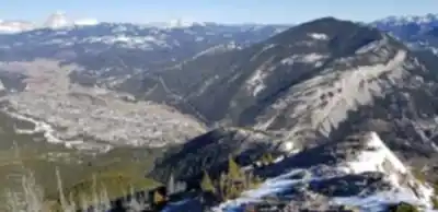
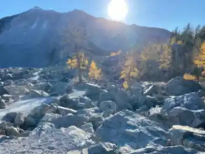
The Turtle Mountain Trail is the area's signature hike, and it earns that reputation. The trail leads you directly through the aftermath of the 1903 Frank Slide, where 82 million tons of limestone crashed down from Turtle Mountain in just 100 seconds. Walking among the massive boulders scattered across the valley floor, the scale of what happened here hits differently than reading about it. The trail continues beyond the slide debris, climbing steadily through mixed forest before opening onto viewpoints that reveal the full sweep of the Crowsnest River valley.
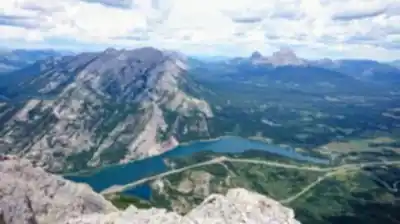
From those elevated positions, the views stretch across multiple mountain ranges. To the west, you can see the peaks that form the Alberta-British Columbia border; eastward, the mountains gradually give way to foothills and open prairie. The contrast is striking — rugged limestone cliffs rising directly from gentle valley bottoms, the kind of dramatic topography that defines this section of the Rockies.
For a completely different experience, the Allison-Chinook Trail offers a gentler introduction to the area. This path winds through lower elevation terrain where wildflower displays peak in July and August. It passes through stands of aspen and poplar that turn gold in fall, while spring brings fresh green growth and the sound of snowmelt streams running alongside the path. The relatively flat terrain and well-maintained surface make it a solid choice for families with young kids or anyone who wants to move at a relaxed pace without sacrificing the scenery.
The trail system here accommodates different fitness levels and time constraints well. Some routes can be completed in under an hour; others push deeper into the backcountry for those wanting a full-day outing. Most trailheads sit around 1,300 metres in elevation, which means you can access alpine-like environments without the punishing elevation gains required elsewhere in the Rockies.
Historical Context
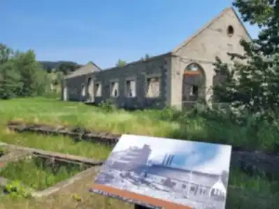
Crowsnest Pass has been a transportation corridor for thousands of years — first for Indigenous peoples, then for European explorers, railway builders, and miners. Coal mining dominated the local economy from the 1890s through the 1950s, and the evidence is still out there if you know where to look. Several trails pass by or through former mining sites where old foundations, equipment, and tailings piles are slowly being reclaimed by forest.
Local museums in Blairmore and Coleman preserve artifacts and stories from the mining era, and spending an hour in one before hitting the trail genuinely changes how you read the landscape around you. The Frank Slide, while devastating to the community at the time, created one of Canada's most accessible geological study sites — a place where you can observe the raw power of mountain-building forces without any technical climbing required.
Terrain and Conditions
Hiking terrain in Crowsnest Pass varies considerably depending on which route you choose. Lower elevation trails typically follow old logging roads or mining access routes, resulting in well-defined paths with moderate grades and packed earth or gravel surfaces that hold up well in most weather. These are the trails where you can move efficiently and focus on what's around you rather than where you're putting your feet.
Higher elevation routes get more demanding — steeper grades, loose rock sections, and real exposure to weather changes. The limestone geology creates interesting features like natural arches, caves, and cliff bands, but it also means surfaces can get slippery fast when wet. Stream crossings show up on several trails; they're usually manageable with careful foot placement, but worth factoring into your planning, especially during spring runoff.
Weather here reflects the area's position on the Continental Divide. Conditions can shift quickly, particularly at elevation. Snow can linger at higher elevations well into May and return as early as September, so checking conditions before you head out is worth the two minutes it takes.
Community and Amenities
Blairmore and Coleman provide the practical support you need without feeling like tourist infrastructure. Both towns have restaurants, gas stations, and basic supplies — selection is limited compared to larger centres, but you won't be stuck. Local cafes function as informal trail information hubs where you can get current conditions and recommendations from people who actually hike these trails regularly. That kind of local knowledge is genuinely useful and not something you'll find on a trailhead sign.
Both communities take real pride in their outdoor recreation opportunities and mining heritage. Residents often know about lesser-used trails and seasonal quirks that can make a meaningful difference to your day out. Using these towns as a base camp rather than just a fuel stop tends to make the whole trip better.
Quick Facts
- Distance: 3.5 km
- Elevation gain: 150 m
- Difficulty: Moderate
- Estimated time: 1 hour 15 minutes
- Region: Southern Rockies, Alberta
Recommended gear for this trail


Ready to go?
Everything you need to know before you goStarting Point
The start of the trails at the crowsnest pass can be accessed by travelling east on Highway 3 from Lethbridge. The trailhead is located just past the Blairmore turnoff.
When?
How much?
- Hiking shoes Essential
- → Salomon Elixir Tour Mid WP · 203.38 $
- Layered clothing Essential
- Rain jacket Essential
- Trekking poles
- → Black Diamond Trail Ergo Cork · 69.99 $
- Headlamp
- → Petzl Actik Core 625 · 103.95 $
FAQ - Frequently asked questions
Everything you need to knowThe Essential Hiking Checklist
Everything you need for your next hike. Bilingual, printable, 1 page.
Download the free checklistSimilar hikes nearby
Discover other trails you might enjoy

Crypt Lake Trail
Southern Rockies
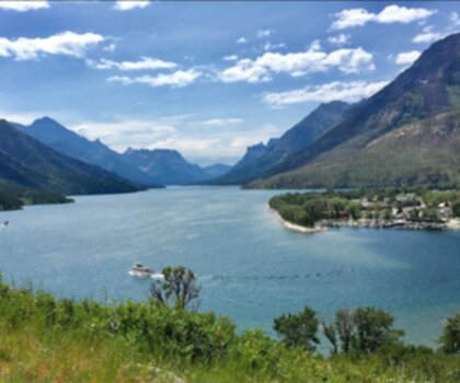
Waterton Lakes National Park of Canada
Southern Rockies

Lundbreck Falls
Southern Rockies

Castle Mountain Resort
Southern Rockies
Blakiston Falls
Southern Rockies
Lower Bertha Falls
Southern Rockies
Hiking near Calgary
120 trails to explore ~163 km away
We work hard to provide the most up-to-date and error-free data possible. If something seems incorrect, let us know! Your contribution helps the whole community.
Hikers' opinions