

Ready to explore Indian Battle Park? Here's everything you need to know before you go!
Discover the trail
Trail description
Description
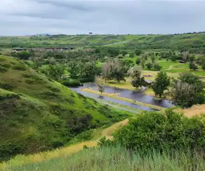
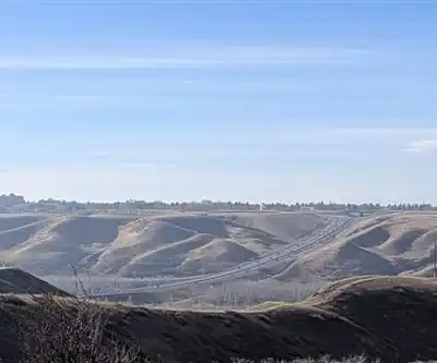
Indian Battle Park sits along the Oldman River in Lethbridge, Alberta, offering a peaceful retreat where prairie meets river valley. Despite its name suggesting Rocky Mountain terrain, this urban park delivers a different kind of natural experience — one shaped by the rolling grasslands of southern Alberta and the dramatic corridor carved by the river over thousands of years.
The park covers roughly 3.2 kilometers of trail and about 50 meters of elevation change, making it an easy outing that most people can complete in around an hour. That said, the variety packed into that short distance is what keeps people coming back.
The Landscape
The Oldman River valley creates a genuine microenvironment here. As you drop down from the prairie level into the valley, the temperature shifts noticeably and the vegetation changes around you. The protected river bottom supports lush, dense growth that contrasts sharply with the drier grasslands above — two distinct worlds separated by just a few dozen meters of elevation.
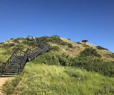
River-level trails move through areas of dense shrubs and scattered trees, giving the walk a more enclosed, intimate feel. The ground stays softer and more humid down here, supporting plant communities you won't find on the exposed prairie above. Valley-side trails, by contrast, cross mixed grassland and scattered tree groves with firmer footing and wide-open views. The modest 50-meter climb might not sound like much, but in this prairie context, it delivers a real shift in perspective — suddenly you're looking out across the full sweep of the valley and the grasslands beyond.
Historical Significance
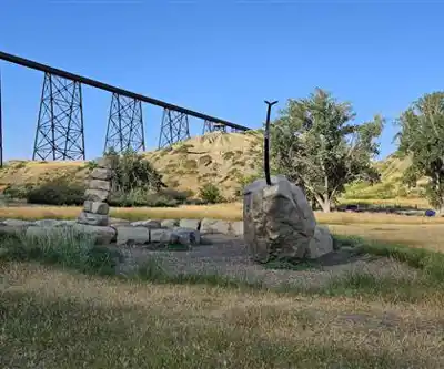
The park's name carries real weight. It commemorates the last great battle between the Cree and Blackfoot First Nations, which took place on this ground in 1870. That conflict marked a turning point in Plains Indigenous history — the end of an era of inter-tribal warfare on the Canadian prairies. Interpretive signs throughout the park provide context about this pivotal event and help visitors understand why this landscape holds deep cultural importance for Indigenous peoples.
Walking here with that history in mind changes the experience. The same river bends and coulees that once provided strategic advantages during the battle now frame scenic viewpoints and wildlife habitat. It's a straightforward trail, but it carries layers that reward a slower pace.
Trail Network
The trail system includes both paved and natural surface paths, which makes the park accessible to a range of abilities and preferences. Easy-going routes follow the river's edge, where the walking stays level and the views focus on the water and the valley walls rising on either side. For those wanting a bit more, trails climbing the valley sides reach higher vantage points with broader views across the prairie landscape.
Multiple access points and parking areas let you start from different sections of the network, so you can tailor the outing to your available time and energy. The park's location within Lethbridge means it's easy to reach without a long drive.
Wildlife and Natural Features
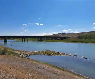
The Oldman River is the park's central natural feature, and its character shifts with the seasons — from high, fast spring flows during runoff to quieter, lower water in late summer. Each phase offers a different read on how the river shapes the landscape and the wildlife communities that depend on it.
Deer are a common sight in the meadow areas, especially during early morning and evening. Their presence reflects the park's role as an urban wildlife corridor, maintaining habitat connectivity in an otherwise developed area. Beaver activity near the riverbanks is worth watching for — chewed stumps, dam structures, and the distinctive V-wake of a swimming beaver are all signs of their ongoing work reshaping the river environment.
Bald eagles use the tall trees along the river as hunting perches and nesting sites, a reliable indicator of a healthy aquatic ecosystem. The varied habitat zones — prairie grassland, valley-side scrub, and river bottom forest — support a solid mix of songbird species as well, making the park a worthwhile stop for anyone with binoculars.
Seasonal Conditions
Spring brings high water and migrating birds, but some lower trails can be muddy or briefly flooded during peak runoff. Summer is the most comfortable season for hiking, with riverside vegetation providing shade and wildflowers adding color to the prairie sections. Fall is particularly striking — deciduous trees along the river turn color against the golden prairie grasses, and the valley takes on a warmth that's easy to linger in. Winter hiking is possible, though ice near the river requires extra care and the exposed prairie sections can be cold when the wind picks up.
Facilities
Picnic areas are scattered throughout the park, with tables and benches positioned to take advantage of the views — some overlooking the river, others facing out across the prairie. Shaded spots near the river offer relief on hot summer days, while more open sites catch the sun during cooler weather. The combination of easy access from Lethbridge, varied terrain, and genuine historical depth makes Indian Battle Park a solid choice for a morning or afternoon outing in southern Alberta.
Recommended gear for this trail


Ready to go?
Everything you need to know before you goStarting Point
The indian battle park is located in the town of Pincher Creek, Alberta. To get to the park, take Highway 6 south from Pincher Creek for about 5 km until you reach the park entrance on your left.
When?
How much?
- Hiking shoes Essential
- → Salomon Elixir Tour Mid WP · 203.38 $
- Layered clothing Essential
- Rain jacket Essential
- Trekking poles
- → Black Diamond Trail Ergo Cork · 69.99 $
- Headlamp
- → Petzl Actik Core 625 · 103.95 $
FAQ - Frequently asked questions
Everything you need to knowThe Essential Hiking Checklist
Everything you need for your next hike. Bilingual, printable, 1 page.
Download the free checklistSimilar hikes nearby
Discover other trails you might enjoy

Crypt Lake Trail
Southern Rockies
Waterton Lakes National Park of Canada
Southern Rockies

Lundbreck Falls
Southern Rockies

Castle Mountain Resort
Southern Rockies
Blakiston Falls
Southern Rockies
Lower Bertha Falls
Southern Rockies
Hiking near Calgary
120 trails to explore ~173 km away
We work hard to provide the most up-to-date and error-free data possible. If something seems incorrect, let us know! Your contribution helps the whole community.
Hikers' opinions