

Ready to explore Le Sentier Un Lac Au Sommet? Here's everything you need to know before you go!
Discover the trail
Trail description
Description
Le Sentier Un Lac Au Sommet is a well-marked, maintained trail in Quebec's Eastern Townships that does exactly what its name promises: it takes you up through forested terrain and delivers you to a lake sitting right at the summit. It's a satisfying structure for a hike—a clear destination, a natural reward, and a straightforward path to get there and back.
What the hike feels like
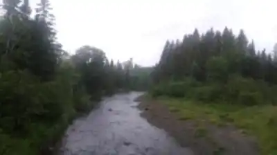
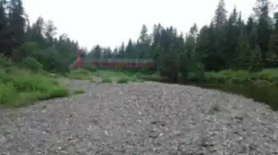
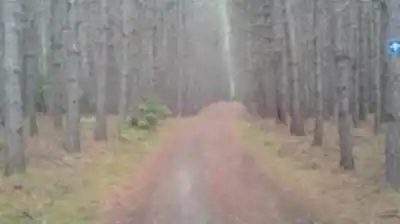
The trail pulls you into the kind of forest the Eastern Townships do well: layered, green, and genuinely quiet. From the first steps, you're in it—not walking alongside nature but actually inside it. The path climbs steadily, and the maintained, clearly marked route means you can stay focused on the experience rather than second-guessing the way forward.
The rhythm of the hike is simple and easy to settle into. You gain elevation gradually, the forest shifts around you as you climb, and the whole thing moves toward one clear payoff. There's no complicated navigation, no scrambling, and no sections that feel out of place with the overall easy rating. It's the kind of trail where you can slow down, look around, and actually enjoy the process of getting somewhere.
Distance, elevation, and difficulty
The trail covers 4.2 km with 300 m of elevation gain and is rated easy. Plan for roughly 2 hours and 15 minutes of total hiking time, though that doesn't account for a longer break at the top—which is worth building in. The effort comes almost entirely from the climb itself rather than from technical terrain, so if you pace yourself and wear footwear with decent grip, the ascent stays comfortable throughout. It's enough elevation to feel like a real hike without tipping into anything strenuous.
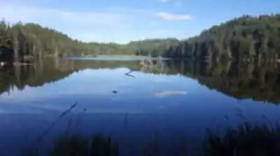
The summit lake
The lake at the top is the reason to come here, and it earns its place as the trail's main event. After the climb through the trees, arriving at open water sitting right at the summit creates a genuine sense of arrival—the kind that makes you want to stop rather than immediately turn around. It's a natural spot to eat, take photos, or simply sit and let the quiet settle in.
The summit area also opens up the views, so you get both the stillness of the lake and a broader look out over the surrounding landscape. That combination—water and elevation together—is what makes this trail feel more complete than a standard out-and-back climb. Treat the summit as the destination it is, not just a turnaround point.
Forest, wildlife, and what to notice along the way
The Eastern Townships are known for rich, layered forest environments, and this trail moves through that kind of terrain the whole way up. The understory is active, the canopy shifts as you gain elevation, and if you're paying attention, there's plenty to notice without going out of your way to look for it.
Wildflowers appear along the route during blooming seasons, and birds are a consistent presence overhead and in the trees. You don't need to be a birder to appreciate the activity—it's just part of the ambient experience of being on a trail that feels genuinely alive. The forest itself does a lot of the work here, especially in autumn when the foliage in the Eastern Townships turns and the tree sections become as much of a draw as the summit.
Seasons and conditions
The trail is open year-round, and the experience shifts meaningfully depending on when you go. Autumn is a strong choice in this region—the foliage color in the Eastern Townships is well known, and on a forested climb like this one, it surrounds you completely. Winter brings a quieter, more stripped-down version of the hike, with snow covering the trail and a different kind of stillness at the top.
Whatever the season, match your preparation to the actual conditions that day. The trail's easy rating holds in good conditions, but wet roots, snow, or ice on the climb can change the feel quickly. Check the weather before you go and adjust your footwear and layers accordingly.
What to bring
Keep it practical. The essentials for this trail are the ones that matter on any hike with elevation gain: sturdy hiking shoes with good grip, enough water for the climb and the time you'll spend at the top, and snacks worth eating at a summit lake. If you're planning to sit at the top for a while—which is worth doing—bring something comfortable to sit on and an extra layer in cooler months.
Because the trail is well-marked and the route is straightforward, you don't need to over-prepare on the navigation side. But the basics of any day hike still apply: know the weather, tell someone your plan, and don't underestimate how much water a 300 m climb will use up.
Why this trail works in the Eastern Townships
The Eastern Townships have a lot of good hiking options, but Le Sentier Un Lac Au Sommet stands out because the destination is so specific. A summit lake isn't something you find on every trail, and it gives this one a clear identity: you know what you're hiking toward, you know what you'll find when you get there, and the experience at the top justifies the climb. Combined with well-maintained trail conditions and the region's forested character, it's a hike that delivers a complete, satisfying outing without requiring a full day or advanced fitness.
Recommended gear for this trail


Ready to go?
Everything you need to know before you goStarting Point
To access the hiking trails, you can start at the main trailhead located at 400 Chemin du Mont, Orford, QC J1X 7A2. There is a parking lot available at this address for visitors. Additionally, another possible starting point is at 200 Rue de la Montagne, Sutton, QC J0E 2K0, where parking facilities are also provided.
When?
Tuesday: 9:00 AM – 5:00 PM
Wednesday: 9:00 AM – 5:00 PM
Thursday: 9:00 AM – 5:00 PM
Friday: 9:00 AM – 5:00 PM
Saturday: 9:00 AM – 5:00 PM
Sunday: 9:00 AM – 5:00 PM
How much?
- Hiking shoes Essential
- → Salomon Elixir Tour Mid WP · 203.38 $
- Layered clothing Essential
- Rain jacket Essential
- Trekking poles
- → Black Diamond Trail Ergo Cork · 69.99 $
- Headlamp
- → Petzl Actik Core 625 · 103.95 $
FAQ - Frequently asked questions
Everything you need to knowTuesday: 9:00 AM – 5:00 PM
Wednesday: 9:00 AM – 5:00 PM
Thursday: 9:00 AM – 5:00 PM
Friday: 9:00 AM – 5:00 PM
Saturday: 9:00 AM – 5:00 PM
Sunday: 9:00 AM – 5:00 PM
The Essential Hiking Checklist
Everything you need for your next hike. Bilingual, printable, 1 page.
Download the free checklistSimilar hikes nearby
Discover other trails you might enjoy

Mount Brome (Bromont)
Eastern Townships

Mont Pinacle
Eastern Townships

Sutton Natural Environment Park
Eastern Townships

Parc De La Gorge De Coaticook
Eastern Townships

Mount Orford National Park
Eastern Townships

Parc national de Frontenac
Eastern Townships
Hiking near Sherbrooke
53 trails to explore ~76 km away
We work hard to provide the most up-to-date and error-free data possible. If something seems incorrect, let us know! Your contribution helps the whole community.
Hikers' opinions