

Ready to explore Marais de la Rivière aux Cerises? Here's everything you need to know before you go!
Discover the trail

Trail description
Description
The Marais de la Rivière-aux-Cerises is one of those places that quietly earns a spot on your must-visit list. Tucked into the Estrie region of Quebec near Magog, this wetland reserve offers a completely different kind of outdoor experience — less about elevation gain and more about slowing down, paying attention, and letting the landscape do the talking.
What Kind of Place Is This?
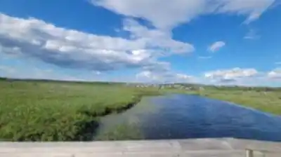
This is a protected wetland and nature reserve centered around a marsh fed by the Rivière-aux-Cerises. The environment here is rich and layered — open water, emergent vegetation, riparian corridors, and the kind of biodiversity that makes naturalists genuinely excited. It's not a mountain hike. It's a flat, accessible exploration of a functioning wetland ecosystem, and that's exactly what makes it worth visiting.
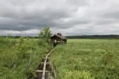
The site offers a network of 7 trails with varying difficulty levels, though most visitors find the experience accessible and family-friendly. The focus is on low-impact access and observation of the wetland environment.
The Trail Experience
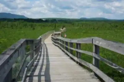
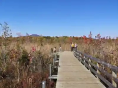
Walking through the Marais de la Rivière-aux-Cerises feels genuinely different from most hikes in Estrie. The main trail is 5.7 km with minimal elevation gain of only 10 m, making it accessible to a wide range of visitors — families with young kids, people looking for an easy outing, or anyone who wants to spend time outdoors without demanding physical effort.
The paths wind through and alongside the marsh, giving you close-up views of open water and dense aquatic vegetation. The terrain is flat throughout, and the pace here is naturally slower. There's no summit to push toward, so most people end up stopping more, looking more, and noticing things they'd walk right past on a conventional trail.
Wildlife and Natural Features
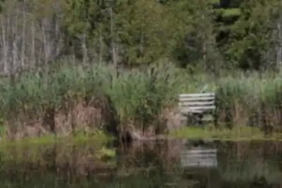
The marsh is a serious wildlife habitat, and that shows up in what you're likely to encounter. Birdwatching is one of the main draws — the wetland attracts a wide variety of waterfowl and marsh birds, and the site is well-regarded among birders in the region. Bring binoculars if you have them.
Beyond birds, the aquatic and semi-aquatic plant life is genuinely impressive if you take the time to look at it. Cattails, water lilies, and other emergent plants create dense, layered habitat that supports the whole food chain. The water itself is clear enough in sections to see what's happening below the surface.
This is also the kind of place where you might spot turtles basking on logs, muskrats moving through the reeds, or dragonflies working the water's edge on a warm afternoon. None of that is guaranteed, but the habitat is right for all of it.
Accessibility and Practical Info
The flat terrain and accessible path infrastructure make this one of the more accessible natural sites in Estrie. It's a good option for visitors who want a genuine nature experience without the physical demands of a traditional hike. The site is well-suited for families, and the manageable distances mean you're not committing to a half-day outing if you don't want to. As with any protected wetland reserve, the rules here are oriented toward conservation. Stay on marked paths, keep noise to a minimum, and leave everything as you found it.
When to Go
Spring and early summer are particularly active at the marsh — water levels are higher, migratory birds are moving through, and the vegetation is coming back to life. That said, the site has something to offer across the warmer months. Fall brings different colors and a quieter atmosphere. Winter access depends on conditions and site management at the time of your visit, so it's worth checking ahead if you're planning an off-season trip.
Getting There
The Marais de la Rivière-aux-Cerises is located near Magog in the Estrie region of Quebec. Check the site's current access information before heading out — parking availability, seasonal hours, and any entry requirements can change, and it's always better to confirm ahead of time rather than show up to a closed gate.
What to Bring
- Binoculars — genuinely useful here, not just a nice-to-have
- Insect repellent — wetland environments mean mosquitoes, especially in spring and early summer
- Waterproof footwear — for muddy edges and side areas
- A field guide or birding app — you'll want to identify what you're seeing
- Camera or phone — the light over open water in the morning or late afternoon is worth capturing
Who It's Best For
The Marais de la Rivière-aux-Cerises works well for a specific kind of visitor: someone who's genuinely curious about the natural world and happy to move at a slower pace. It's ideal for birders, nature photographers, families with young children, and anyone who finds value in a walk that's more about observation than distance covered.
If you're coming from elsewhere in Estrie and looking to round out a trip that already includes more demanding hikes, this makes an excellent contrast — a low-effort, high-reward stop that shows a completely different side of the region's natural landscape.
Recommended gear for this trail


Ready to go?
Everything you need to know before you goStarting Point
To access the hiking trails, head to the main trailhead located at 69 Chemin Roy, Magog, QC J1X 0N4. There is a parking lot available at this address for visitors.
When?
How much?
- Hiking shoes Essential
- → Salomon Elixir Tour Mid WP · 203.38 $
- Layered clothing Essential
- Rain jacket Essential
- Trekking poles
- → Black Diamond Trail Ergo Cork · 69.99 $
- Headlamp
- → Petzl Actik Core 625 · 103.95 $
FAQ - Frequently asked questions
Everything you need to knowThe Essential Hiking Checklist
Everything you need for your next hike. Bilingual, printable, 1 page.
Download the free checklistSimilar hikes nearby
Discover other trails you might enjoy

Mount Brome (Bromont)
Eastern Townships

Mont Pinacle
Eastern Townships

Sutton Natural Environment Park
Eastern Townships

Parc De La Gorge De Coaticook
Eastern Townships

Mount Orford National Park
Eastern Townships

Parc national de Frontenac
Eastern Townships
Hiking near Sherbrooke
53 trails to explore ~26 km away
We work hard to provide the most up-to-date and error-free data possible. If something seems incorrect, let us know! Your contribution helps the whole community.
Hikers' opinions