

Ready to explore Mont Chauve? Here's everything you need to know before you go!
Discover the trail
Available trails
| Trails | Distance | Elevation | Duration | Difficulty | GPX |
|---|---|---|---|---|---|
| 9.6 km | 470 m | 3h | Beginner |
Trail description
Description
Mont Chauve is one of the more rewarding hikes in the Eastern Townships — a mountain that punches above its weight when it comes to the payoff at the top. The name says it all: "Bald Mountain" earns its nickname with an open, rocky summit that trades the usual tree-framed peekaboo views for something genuinely wide and unobstructed. For a region full of forested ridgelines, that kind of exposed summit is worth seeking out.
The basics
The loop trail covers 9.6 kilometers with 470 meters of elevation gain, and most hikers complete it in around 3 hours 30 minutes. The difficulty is rated easy, which fits the character of the route well — the ascent is consistent and steady rather than technical, and the trail is well-maintained throughout. It's the kind of hike where you can focus on the experience rather than constantly watching your footing.
What the trail actually feels like
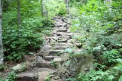
The route starts in dense woodland and stays there for a good stretch. Shaded canopy, soft forest floor, the gradual sound of the outside world fading — it's a proper forest walk before it becomes a summit hike. As you gain elevation, the trees thin and the air shifts. That transition is one of the more satisfying parts of the day: you feel the climb happening, the light changes, and then the summit opens up in a way that feels earned.
The loop format works well here. Going up one way and coming down another keeps the route from feeling repetitive, and it gives you a slightly different read on the terrain in each direction. The trail is clear and well-marked, so navigation is straightforward — this isn't a route where you'll be second-guessing yourself at junctions.
The summit
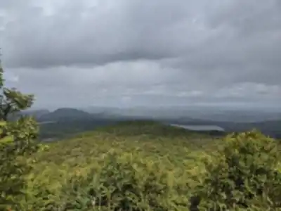
The open, rocky expanse at the top of Mont Chauve is the main event, and it delivers. At 650 meters, the elevation isn't extreme, but the bare summit creates sightlines that feel much bigger than the number suggests. On a clear day, you can see out to Lake Memphremagog and catch views toward Vermont's Green Mountains to the south. The openness also means you'll feel the weather directly up here — wind, sun, or shifting clouds all hit differently than they do in the forest below.
It's a natural spot to stop, eat, and take your time. The flat rock gives you room to spread out, and the view holds your attention long enough that a proper break makes sense. Pack your lunch so it's easy to access — you'll want to stay a while.
Terrain and scenery along the way
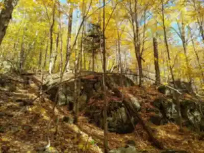
The forest sections of the trail are lush and varied, with wildflowers adding color in the warmer months. The canopy keeps things cool and shaded on hot days, which makes the mid-hike stretch genuinely pleasant rather than just a means to an end. Wildlife is part of the picture too — deer move through this habitat, and birdsong is a consistent presence throughout the forest sections. A slower pace in the quieter parts of the trail makes sightings more likely.
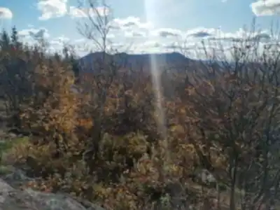
The shift from forest floor to open rock near the summit is one of those terrain changes that marks a clear moment in the hike. It's not subtle — you step out of the trees and onto something that feels completely different underfoot and overhead.
Seasons on the mountain
- Spring and summer: The forest is at its most lush, wildflowers are out along the trail, and the shaded sections offer real relief on warm days. The summit views are sharp and clear when the weather cooperates.
- Autumn: This is when Mont Chauve really stands out. The open summit gives you a panoramic view of the fall color change across a wide stretch of the Eastern Townships — reds, oranges, and golds as far as you can see. It's a popular time for photographers, and for good reason.
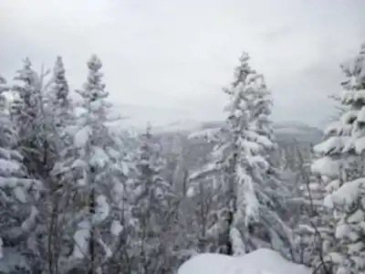
- Winter: The trail takes on a quieter character under snow. Snowshoeing is a natural fit for the terrain, and the open summit in winter has its own stark appeal — bright, muted, and dramatically different from the green-season experience.
Who it works for
The easy rating and loop format make Mont Chauve a solid option for a wide range of hikers. Families with older kids who are comfortable with a few hours on trail will find the summit reward well worth the effort. More experienced hikers will appreciate the quality of the views and the satisfying rhythm of the ascent, even if the overall challenge is moderate. It's not a beginner's first hike, but it's well within reach for anyone who hikes regularly.
A few practical notes
Stick to the marked trails throughout, especially on the open summit where it's tempting to wander across the rock. The exposed area is part of what makes the summit special — keeping foot traffic on established paths helps preserve it. Bring enough water for the full loop, and pack out everything you bring in. These are well-traveled trails, and the condition of the mountain reflects how well hikers look after it.
Services and amenities
This information may vary by season.
Recommended gear for this trail


Ready to go?
Everything you need to know before you goStarting Point
To access the hiking trails, you can start at the main trailhead located at 400 Chemin de la Montagne, Eastman, QC J0E 1P0. There is a parking lot available at this location. Additionally, another possible starting point is at 100 Rue du Parc, Orford, QC J1X 7A2, which also offers parking facilities.
When?
How much?
- Hiking shoes Essential
- → Salomon Elixir Tour Mid WP · 203.38 $
- Layered clothing Essential
- Rain jacket Essential
- Trekking poles
- → Black Diamond Trail Ergo Cork · 69.99 $
- Headlamp
- → Petzl Actik Core 625 · 103.95 $
FAQ - Frequently asked questions
Everything you need to knowThe Essential Hiking Checklist
Everything you need for your next hike. Bilingual, printable, 1 page.
Download the free checklistSimilar hikes nearby
Discover other trails you might enjoy

Mount Brome (Bromont)
Eastern Townships

Mont Pinacle
Eastern Townships

Sutton Natural Environment Park
Eastern Townships

Parc De La Gorge De Coaticook
Eastern Townships

Mount Orford National Park
Eastern Townships

Parc national de Frontenac
Eastern Townships
Hiking near Sherbrooke
53 trails to explore ~25 km away
We work hard to provide the most up-to-date and error-free data possible. If something seems incorrect, let us know! Your contribution helps the whole community.
Hikers' opinions