

Ready to explore Mont Echo? Here's everything you need to know before you go!
Discover the trail

Trail description
Description
Mont Echo is one of those hiking destinations in Québec's Eastern Townships that doesn't get as much attention as it deserves. It sits within the Parc d'environnement naturel de Sutton (PENS), a managed natural area where the focus is on keeping the environment intact while giving hikers room to move through it properly. The result is a trail experience that feels genuine — wooded, physical, and rewarding in a way that sticks with you after the day is done.
The numbers: what you're signing up for
This is not a casual outing. Mont Echo covers 4.2 km with 750 m of elevation gain, which puts it firmly in the hard category — and that rating is earned. The estimated time on trail is around 3 hours 15 minutes, though your actual time will depend on your pace, how long you linger at the top, and how technical the conditions are underfoot. If you're going with a mixed group or haven't been hiking much lately, budget more time and don't rush the descent.
The elevation gain is the defining feature here. At 750 m over 4.2 km, you're climbing consistently and steeply for much of the route. That's the kind of gradient that demands solid footwear with real traction, not trail runners you've been meaning to replace. Come prepared for the physical effort, and the payoff at the top makes sense.
What the trail feels like on the way up
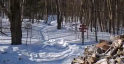
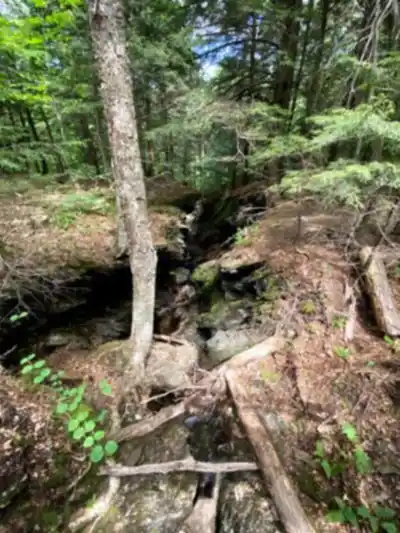
The climb through Mont Echo moves you through classic Eastern Townships forest — dense, shaded, and layered in a way that keeps the scenery from feeling monotonous even when the grade is relentless. The forest character shifts as you gain elevation: the understory changes, the canopy opens and closes, and the light comes through differently depending on where you are on the slope. It's the kind of terrain that rewards paying attention.
The trails are well-marked and maintained, which matters on a hike like this where the combination of steep terrain and forest cover could otherwise make navigation stressful. Good signage means you can focus on the climb rather than second-guessing junctions. The trail network also offers some variety in terms of how you approach the summit, which makes it possible to shape the outing to your group's ability and goals.
Wildlife and plant life are part of the experience here. The area supports diverse flora and fauna, and slowing down occasionally — especially in the quieter forested sections — gives you a better chance of noticing what's around you. Bird activity in particular tends to be more noticeable when you're moving at a steady, unhurried pace rather than pushing hard the whole way.
The summit: where the effort pays off
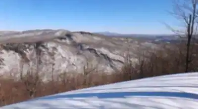
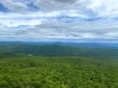
The top of Mont Echo delivers panoramic views across the surrounding landscape — the kind of open, far-reaching perspective that makes the climb feel worth every steep section. This is the natural place to stop, eat something, and take your time before heading back down. Don't rush it. The summit is the point the whole hike builds toward, and spending fifteen or twenty minutes up there rather than immediately turning around is almost always the right call.
If you're bringing a camera or shooting with your phone, clear days give you the best long-distance visibility, but even a partly cloudy sky adds depth and texture to the landscape below. The viewpoint is popular enough that you may be sharing it with other hikers, so a little patience goes a long way when everyone wants the same angle.
Beyond the hike: what PENS adds to your day
Because Mont Echo sits within PENS, your visit doesn't have to end when the trail does. The park supports low-key activities like bird watching and picnicking, which makes it a practical option if you're hiking with people who want different things out of the day. A common approach: hike first while energy is high, then settle into a slower pace afterward — find a good spot, spread out a meal, and spend some time watching the treeline.
The park's management philosophy is oriented around preserving natural habitats, and that shows in how the area feels. It's not a heavily developed destination. The infrastructure is there to support your visit without overwhelming the environment, and that balance is part of what makes the experience feel worthwhile.
Practical preparation
Given the difficulty rating and the elevation involved, preparation matters more here than on an easier trail. A few things worth doing before you leave:
- Check weather and trail conditions: Wet or icy conditions on a 750 m climb change the difficulty significantly. Know what you're walking into before you go.
- Get the trail map: Maps are available through the PENS visitor center or online. Reviewing the route ahead of time helps you choose the right option for your group and manage your time on trail.
- Pack the basics: Water is non-negotiable on a climb like this, even on cooler days. Bring enough snacks to fuel the ascent and enjoy a proper break at the summit. Footwear with solid traction and layers that match the forecast will make the difference between a comfortable day and a frustrating one.
If you're looking for a hike in the Eastern Townships that gives you real elevation, genuine forest immersion, and a summit view that earns its reputation, Mont Echo is a strong choice — just go in knowing it will ask something of you.
Recommended gear for this trail


Ready to go?
Everything you need to know before you goStarting Point
The trailhead for the Mount Echo trails is located at the intersection of Mont-Echo and Promenade-des-Ancêtres streets.
To get to the Mount Echo trails, you must go to the municipality of Saint-Étienne-de-Bolton, located about an hour and a half's drive from Montreal.
To get to the Mount Echo trails, you must go to the municipality of Saint-Étienne-de-Bolton, located at 905 Chemin des Patriotes Nord.
When?
How much?
- Hiking shoes Essential
- → Salomon Elixir Tour Mid WP · 203.38 $
- Layered clothing Essential
- Rain jacket Essential
- Trekking poles
- → Black Diamond Trail Ergo Cork · 69.99 $
- Headlamp
- → Petzl Actik Core 625 · 103.95 $
FAQ - Frequently asked questions
Everything you need to knowThe Essential Hiking Checklist
Everything you need for your next hike. Bilingual, printable, 1 page.
Download the free checklistSimilar hikes nearby
Discover other trails you might enjoy

Mount Brome (Bromont)
Eastern Townships

Mont Pinacle
Eastern Townships

Sutton Natural Environment Park
Eastern Townships

Parc De La Gorge De Coaticook
Eastern Townships

Mount Orford National Park
Eastern Townships

Parc national de Frontenac
Eastern Townships
Hiking near Sherbrooke
53 trails to explore ~57 km away
We work hard to provide the most up-to-date and error-free data possible. If something seems incorrect, let us know! Your contribution helps the whole community.
Hikers' opinions