

Ready to explore Mont Gosford? Here's everything you need to know before you go!
Discover the trail
Available trails
| Trails | Distance | Elevation | Duration | Difficulty | GPX |
|---|---|---|---|---|---|
| 2.2 km | 29min | Beginner | |||
| 1 km | 200 m | 32min | Beginner | ||
| 2.5 km | 33min | Beginner | |||
| 25.2 km | 5h30 | Intermediate | |||
| 3.2 km | 400 m | 1h30 | Intermediate | ||
| 6.8 km | 1h30 | Intermediate | |||
| 2.2 km | 29min | Intermediate | |||
| 9.4 km | 2h | Intermediate | |||
| 81 km | 540 m | 19h | Advanced |
Trail description
Description
Mont Gosford sits in the heart of the Réserve faunique Papineau-Labelle region of Estrie, Quebec, and it holds a special distinction: it's the highest peak in southern Quebec and the highest accessible mountain in southeastern Quebec. That alone makes it worth the trip for anyone who takes their hiking seriously. But beyond the bragging rights, this mountain delivers a genuine backcountry experience that's harder to find as more trails get developed and groomed across the province.
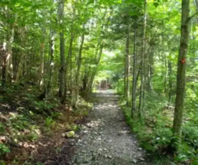
This isn't a casual afternoon stroll. Mont Gosford demands real effort, and the reward is a summit that genuinely earns its reputation. The approach takes you through dense boreal forest, across rocky terrain, and up slopes that remind you why you trained. The trail is maintained but not over-managed — you'll feel like you're actually in the wilderness, not walking through a park.
The Summit Experience
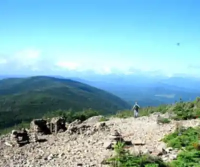
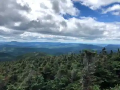
Reaching the top of Mont Gosford is the kind of moment that sticks with you. On a clear day, the panoramic view stretches across rolling forested hills in every direction, with no urban sprawl cutting into the horizon. The Appalachian landscape from this vantage point looks exactly like what it is: old, wild, and largely untouched. You're looking at one of the most intact forest ecosystems in southern Quebec.
The summit itself is rocky and open enough to give you a proper 360-degree view. There's a fire tower at the top — a classic piece of Quebec backcountry infrastructure — that adds both character and an extra vantage point if you want to climb it. From up there, the scale of the surrounding terrain really hits you.
The Trail and Terrain
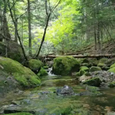
The route to the summit winds through mixed and boreal forest, with the tree cover shifting as you gain elevation. Lower sections move through hardwood and mixed forest typical of Estrie, while the upper slopes transition into the kind of dense conifer forest you'd expect closer to the summit of a significant Appalachian peak. The trail surface varies — expect rooted sections, exposed rock, and some steeper pitches that require you to watch your footing.
The terrain is genuinely challenging in places. This isn't a trail where you can zone out and cruise on autopilot. Trekking poles are a smart call, especially on the descent when your legs are tired and the rocky sections demand attention. Good footwear with ankle support is worth it here.
Wildlife and Forest
The forests around Mont Gosford are home to the kind of wildlife you'd expect from a large, relatively undisturbed natural area in Quebec. The boreal and mixed forest habitat supports a healthy range of bird species, and the area is known for its biodiversity. Moose are present in the region, and the intact forest corridor makes this a meaningful piece of the broader Appalachian ecosystem.
Because this area doesn't see the same foot traffic as more accessible peaks in Estrie, wildlife encounters are genuinely possible. Keep your eyes open, especially in the early morning or late afternoon, and keep noise to a reasonable level on the trail.
Practical Information
Mont Gosford is located within a managed natural area, and access is organized accordingly. The trailhead has parking available, and the site is managed to preserve the natural environment. Given the remote character of this mountain, it's worth checking current access conditions and any fees or permits required before you head out — these details can change seasonally.
Cell service in this area is limited to nonexistent once you're on the trail, which is part of the appeal but also means you need to be prepared. Download offline maps before you leave, carry more water than you think you need, and make sure someone knows your plan. The remoteness of Mont Gosford is one of its best qualities, but it also means self-sufficiency matters more here than on a busy day-use trail.
Best Seasons
Summer and fall are the prime seasons for Mont Gosford. The fall foliage in Estrie is exceptional, and from the summit of this prominent Appalachian peak, the view across the autumn forest is hard to beat. Summer offers longer days and reliable trail conditions, though the forest provides good shade on the ascent.
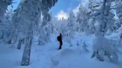
Spring access can be limited depending on snowmelt and trail conditions — the higher elevation means snow lingers longer here than at lower-elevation trails in the region. Winter ascents are possible for experienced hikers with the right gear, but this is serious terrain in winter conditions and should be treated accordingly. Note that some trails are closed in winter.
Who This Trail Is For
Mont Gosford is best suited for hikers who are comfortable with sustained effort and uneven terrain. If you've done a handful of day hikes and want to push yourself toward something more demanding, this is a solid next step. If you're an experienced hiker looking for a peak that delivers genuine backcountry character without requiring a multi-day expedition, Mont Gosford fits the bill.
It's not the right choice for young children or anyone who isn't comfortable on rocky, rooted trails with significant elevation gain. But for hikers who want to stand on the highest peak in southern Quebec and earn that view through real effort, this mountain delivers exactly what it promises.
Getting There
Mont Gosford is located in the Estrie region of Quebec, near Woburn. The access road to the trailhead is rural, and navigation apps don't always handle the final approach well — it's worth researching the specific access route before you leave and having a backup navigation option that doesn't rely on cell service. Give yourself extra time for the drive, especially if you're coming from outside the immediate region.
Arriving early is always a good idea on a mountain like this — it gives you the best chance of clear summit views before afternoon clouds build, and it means you're not finishing the descent in fading light.
Services and amenities
This information may vary by season.
Recommended gear for this trail


Ready to go?
Everything you need to know before you goStarting Point
To access the hiking trails, head towards the main trailhead located at 2692 Route du mont gosford, Saint-Augustin-de-Woburn, QC G0Y 1R0. This is the primary entry point where you can find parking facilities.
When?
How much?
- Hiking shoes Essential
- → Salomon Elixir Tour Mid WP · 203.38 $
- Layered clothing Essential
- Rain jacket Essential
- Trekking poles
- → Black Diamond Trail Ergo Cork · 69.99 $
- Headlamp
- → Petzl Actik Core 625 · 103.95 $
FAQ - Frequently asked questions
Everything you need to knowThe Essential Hiking Checklist
Everything you need for your next hike. Bilingual, printable, 1 page.
Download the free checklistSimilar hikes nearby
Discover other trails you might enjoy

Mount Brome (Bromont)
Eastern Townships

Mont Pinacle
Eastern Townships

Sutton Natural Environment Park
Eastern Townships

Parc De La Gorge De Coaticook
Eastern Townships

Mount Orford National Park
Eastern Townships

Parc national de Frontenac
Eastern Townships
Hiking near Sherbrooke
53 trails to explore ~81 km away
We work hard to provide the most up-to-date and error-free data possible. If something seems incorrect, let us know! Your contribution helps the whole community.
Hikers' opinions