

Ready to explore Mont Saint-Joseph? Here's everything you need to know before you go!
Discover the trail


Trail description
Description
Mont Saint-Joseph is a well-established hiking destination located within Parc national du Mont-Mégantic, near Chartierville and Notre-Dame-des-Bois in Quebec's eastern Townships. This mountain has earned a solid reputation among regional hikers and offers a rewarding experience that combines natural beauty, legitimate elevation gain, and views that justify the effort involved.
The Setting
The mountain rises within the Mont-Mégantic national park system, an area known for its Appalachian landscape characterized by hardwood forests, rocky outcrops, and open ridgelines. As you gain elevation, the forest composition shifts from mature hardwoods in the lower sections to more mixed growth higher up. The setting provides the typical mix of shaded forest floor and more exposed sections where views open up.
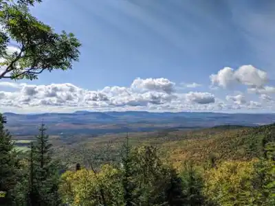
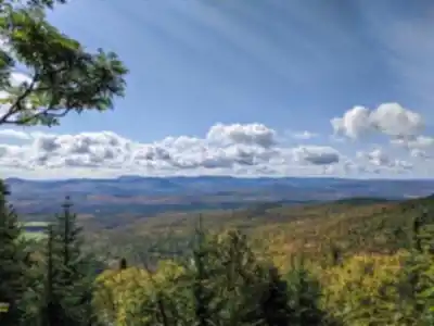
The Summit Experience
At the top of Mont Saint-Joseph stands a small historic chapel built in 1913, a must-see landmark that adds genuine character to the summit experience. The chapel itself is worth taking time to appreciate. From the summit area, hikers are positioned approximately one kilometer from Twilight peak, and the panoramic views stretch across the surrounding landscape on clear days. The summit area has adequate space to rest, eat, and absorb the vista before descending.
The Trail
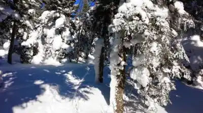
The route to the summit moves through mature forest with typical Appalachian trail conditions—a mix of roots, rocks, and packed earth. The approach is engaging without being overly punishing. As elevation increases, the forest opens progressively, and the effort begins to yield visible rewards. The return trail is described as easy and pleasant in all seasons, making the overall experience accessible to hikers with moderate fitness and experience.
Flora and Wildlife
The forest composition includes sugar maple, yellow birch, and beech in lower and mid-elevation sections, with mixed and coniferous growth appearing at higher elevations. This makes for exceptional foliage displays in fall. The forest habitat supports white-tailed deer, songbirds, and occasional larger mammals. Raptors are sometimes observed riding thermals above the ridgeline.
Practical Information
- Location: Parc national du Mont-Mégantic, Chartierville/Notre-Dame-des-Bois, Quebec
- Distance: 6.4 km (or 7.2 km for loop trail option)
- Elevation gain: 1071 m (approximately 3515 feet)
- Estimated duration: 3 hours 15 minutes
- Trail type: Out-and-back to summit, with loop trail option available
- Difficulty: Moderate to moderately challenging
- Best seasons: Spring through fall; fall particularly excellent for foliage
- Notable feature: Historic chapel at summit (built 1913)
The trail is well-maintained and regularly hiked, creating clear, established routes. Weekend popularity is significant, and early arrival is recommended to secure parking and avoid crowds. Trail conditions should be checked before visiting, particularly during shoulder seasons when snow or mud may affect upper sections.
Who It's Good For
This hike suits hikers with moderate experience and reasonable fitness. It's accessible for families with older children comfortable on uneven terrain, while also offering genuine satisfaction for more experienced hikers. The 3+ hour commitment makes it a solid half to full-day outing depending on pace and summit time. It works well as a standalone destination or as part of a broader exploration of the Mont-Mégantic region.
Getting the Most Out of Your Visit
Start early to enjoy morning light at the summit and experience the viewpoint before midday crowds arrive. Bring adequate water and food, as no services exist on the mountain. Sturdy footwear with ankle support is essential given rocky sections near the summit. Fall visits during peak foliage season (typically through October) create particularly memorable experiences.
Services and amenities
This information may vary by season.
Recommended gear for this trail


Ready to go?
Everything you need to know before you goStarting Point
To access the hiking trails, head to the main trailhead located at 1245 Chemin du Mont Saint-Joseph, Valcourt, QC J0E 2L0. There is a parking lot available at this address for visitors.
When?
How much?
- Hiking shoes Essential
- → Salomon Elixir Tour Mid WP · 203.38 $
- Layered clothing Essential
- Rain jacket Essential
- Trekking poles
- → Black Diamond Trail Ergo Cork · 69.99 $
- Headlamp
- → Petzl Actik Core 625 · 103.95 $
FAQ - Frequently asked questions
Everything you need to knowThe Essential Hiking Checklist
Everything you need for your next hike. Bilingual, printable, 1 page.
Download the free checklistSimilar hikes nearby
Discover other trails you might enjoy

Mount Brome (Bromont)
Eastern Townships

Mont Pinacle
Eastern Townships

Sutton Natural Environment Park
Eastern Townships

Parc De La Gorge De Coaticook
Eastern Townships

Mount Orford National Park
Eastern Townships

Parc national de Frontenac
Eastern Townships
Hiking near Sherbrooke
53 trails to explore ~60 km away
We work hard to provide the most up-to-date and error-free data possible. If something seems incorrect, let us know! Your contribution helps the whole community.
Hikers' opinions