

Ready to explore Sentiers Des Carrières Historiques - Maison du Granit? Here's everything you need to know before you go!
Discover the trail
Trail description
Description
Sentiers Des Carrières Historiques is one of those trail networks in the Eastern Townships that earns its place on a day-trip list for reasons beyond just the distance. At 18.8 km with 200 m of elevation gain, it's a full outing—but the real draw is what you're walking through: a landscape that used to be an active quarrying area, now reclaimed by forest, and still carrying visible traces of that past.
What sets this place apart
Most trail systems in the Eastern Townships offer great scenery. What makes Sentiers Des Carrières Historiques different is the layer of industrial history woven into the route. You're not walking through a reconstructed heritage site or reading plaques from a distance—you're moving through actual terrain that was shaped by quarry work, where the stone cuts and remnants are still present in the landscape. Nature has grown back around them, which creates an interesting contrast: old rock formations sitting inside a living forest, with the sense that the land has quietly shifted from one purpose to another over time.
That contrast is worth paying attention to as you hike. The quarry remnants aren't dramatic landmarks you'll check off a list—they're more subtle than that, and part of the experience is noticing how the terrain changes as you move between natural forest and the older, stone-dominant sections.
Trail basics
- Trail name: Sentiers Des Carrières Historiques
- Region: Eastern Townships (Cantons-de-l'Est), Quebec
- Distance: 18.8 km
- Elevation gain: 200 m
- Difficulty: Easy
- Estimated time: 5h30
Terrain and pacing
The "easy" rating is accurate, but it doesn't mean flat. Over 18.8 km, the 200 m of elevation gain spreads out as gentle rises and dips rather than any sustained climb. You can keep a steady rhythm throughout without needing to stop and recover—which is part of why the estimated 5h30 is realistic for most hikers. You'll cover real ground, but the effort stays manageable.
The trail network is well-marked, which matters on a longer route where you might be tempted to follow a side path toward an interesting rock formation. Staying oriented is straightforward, so you can focus on what's around you rather than on navigation.
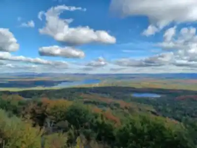
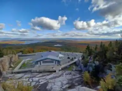
The terrain itself is typical Eastern Townships: rolling hills, dense mixed forest, and calm water features at various points along the route. The forested sections feel enclosed and quiet—sounds soften, the canopy closes in, and it becomes easier to notice smaller details like changes in ground cover or bird activity. The water features shift the mood entirely, offering a natural place to slow down and take a break without it feeling forced.
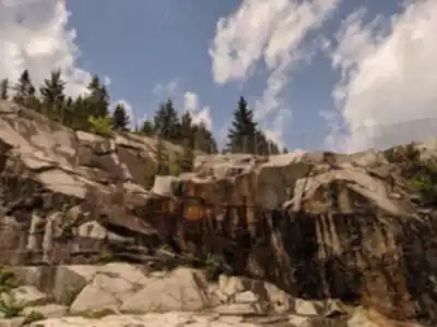
The quarry landscape: what to look for
The historic quarries are the defining feature of this trail system, and they reward hikers who slow down rather than push through. As you walk, you're crossing terrain that was once actively worked for stone—and that history is still readable in the landscape if you're paying attention. Look for the places where the rock face is more exposed, where the ground drops away in ways that don't quite match the natural topography, or where old stone sits in contrast to the surrounding vegetation.
The most interesting moments tend to come when you stop trying to cover distance and instead take a few minutes to look at how the route threads between natural growth and the older quarry features. It's an easy place to have a conversation while walking, but it's also an easy place to slip into a quieter pace and just take in what's around you.
Wildlife and seasonal changes
The forested stretches of Sentiers Des Carrières Historiques bring you close to the local wildlife in a way that feels natural rather than staged. Native birds are active throughout—you'll often hear them before you see them, moving quickly between branches in the denser sections. Small mammals occasionally cross the trail, a reminder that you're passing through an active habitat rather than a managed park path.
The seasonal shifts are worth factoring into when you visit. Autumn is particularly strong here: the leaf color transforms the forest sections and makes familiar stretches look completely different from one week to the next. Summer offers full canopy cover and lush undergrowth. If you're the type to return to the same trail more than once, this is a network where repeat visits feel genuinely different depending on the time of year.
Who this hike works for
The combination of easy difficulty and 18.8 km of distance makes this a practical choice for a wide range of hikers. It's long enough to feel like a real day out, but the terrain doesn't require technical skill or a high fitness baseline. That makes it a solid option when you're planning for a group with mixed abilities—everyone can move at their own pace without the route becoming a problem for anyone.
Families with older kids who are comfortable with longer distances will find plenty to hold their attention: the quarry remnants give you something to talk about and look for, and the variety of terrain—forest, hills, water—keeps the walking from feeling repetitive. Solo hikers looking for that quieter Eastern Townships experience will also find it here, particularly in the more enclosed forest sections where the trail feels like your own space even though it's clearly established and easy to follow.
Extending your day
If you want to turn this into a full-day outing rather than just a hike, the area supports it. There are options for picnicking nearby, and the scenery along the route—forest, water, and rolling hill views—gives you plenty of natural spots to settle into for a while. For those looking to stay longer, camping options in the area mean you can use Sentiers Des Carrières Historiques as the anchor for a broader Eastern Townships stay: hike during the day, then extend the experience into the evening without needing to rush back out.
Recommended gear for this trail


Ready to go?
Everything you need to know before you goStarting Point
The Sentiers Des Carrières Historiques hiking trails have several trailheads you can access. One primary starting point is located at 37 Chemin de la Carrière, Stanstead, QC J0B 3E0. Another possible trailhead can be found at 15 Rue Principale, Stanstead, QC J0B 3E5. Both locations offer parking facilities for visitors.
When?
Tuesday: Closed
Wednesday: Closed
Thursday: Closed
Friday: Closed
Saturday: 10:00 AM – 5:00 PM
Sunday: 10:00 AM – 5:00 PM
How much?
- Hiking shoes Essential
- → Salomon Elixir Tour Mid WP · 203.38 $
- Layered clothing Essential
- Rain jacket Essential
- Trekking poles
- → Black Diamond Trail Ergo Cork · 69.99 $
- Headlamp
- → Petzl Actik Core 625 · 103.95 $
FAQ - Frequently asked questions
Everything you need to knowTuesday: Closed
Wednesday: Closed
Thursday: Closed
Friday: Closed
Saturday: 10:00 AM – 5:00 PM
Sunday: 10:00 AM – 5:00 PM
The Essential Hiking Checklist
Everything you need for your next hike. Bilingual, printable, 1 page.
Download the free checklistSimilar hikes nearby
Discover other trails you might enjoy

Mount Brome (Bromont)
Eastern Townships

Mont Pinacle
Eastern Townships

Sutton Natural Environment Park
Eastern Townships

Parc De La Gorge De Coaticook
Eastern Townships

Mount Orford National Park
Eastern Townships

Parc national de Frontenac
Eastern Townships
Hiking near Sherbrooke
53 trails to explore ~85 km away
We work hard to provide the most up-to-date and error-free data possible. If something seems incorrect, let us know! Your contribution helps the whole community.
Hikers' opinions