

Ready to explore Station Touristique Mont Owl's Head? Here's everything you need to know before you go!
Discover the trail
Available trails
| Trails | Distance | Elevation | Duration | Difficulty | GPX |
|---|---|---|---|---|---|
| 2 km | 540 m | 1h30 | Intermediate | ||
| 1.2 km | 0 m | 16min | Intermediate | ||
| 3.2 km | 540 m | 1h30 | Advanced | ||
| 5.4 km | 540 m | 2h | Advanced |
Trail description
Description
Station Touristique Mont Owl's Head sits on the eastern shore of Lake Memphremagog in Quebec's Eastern Townships, and while most people know it as a ski resort, it's also a legitimate hiking destination that doesn't get nearly the attention it deserves. The mountain rises sharply from the lakeshore, and that geography shapes everything about the experience here — the views, the terrain, and the way the trails feel underfoot.
The Setting
Mont Owl's Head gets its name from the distinctive silhouette the summit creates against the sky, which early settlers thought resembled an owl's head in profile. Whether you see it or not, the name has stuck for good reason — this mountain has a character all its own. It sits at the southern edge of the Eastern Townships, close to the Vermont border, in a landscape defined by rolling forested hills, farmland, and the long blue stretch of Lake Memphremagog cutting through the valley below.
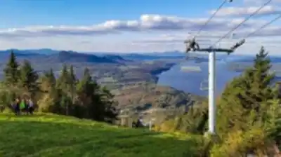
The resort infrastructure — lifts, lodges, groomed runs — is all here, but when you're on the hiking trails, especially once you get above the treeline or into the wooded sections away from the ski corridors, it feels like proper backcountry. The forest is dense, the terrain is varied, and the mountain earns its reputation as one of the more rewarding hikes in the Estrie region.
The Terrain
The trails at Mont Owl's Head cover a range of terrain types. Lower sections move through mixed hardwood and conifer forest, with the kind of rooted, rocky footing that keeps you paying attention. As you gain elevation, the forest transitions and the trail character changes — steeper pitches, more exposed rock, and sections where you're scrambling rather than simply walking.
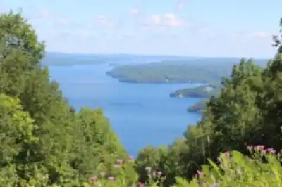
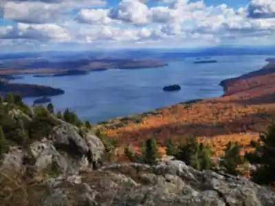
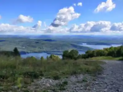
The upper mountain offers some of the best views in the Eastern Townships. From the higher vantage points, Lake Memphremagog spreads out below you in both directions, and on a clear day you can see well into Vermont to the south. The panorama is genuinely impressive — this is one of those summits where the effort feels immediately justified the moment the trees open up.
The terrain is honest. It doesn't pretend to be easier than it is. There are sections that will challenge hikers who aren't used to sustained elevation gain, and the rocky stretches require solid footwear. That said, the trails are well-established and the mountain sees enough traffic that route-finding isn't a concern on the main paths.
What Makes This Place Stand Out
A few things set Mont Owl's Head apart from other hiking destinations in the Eastern Townships:
- The lake views: Lake Memphremagog is one of the most scenic bodies of water in Quebec, and Mont Owl's Head gives you one of the best elevated perspectives on it. The combination of mountain terrain and lake views in a single hike is relatively rare in this region.
- The proximity to the Vermont border: The cross-border landscape gives this corner of the Eastern Townships a particular feel — the hills roll on in every direction without a hard edge, and the views reflect that openness.
- The resort base: Having a ski resort at the base means there are facilities available — parking, washrooms, and a lodge — that you won't find at more remote trailheads. This makes logistics straightforward, especially for families or groups with mixed experience levels.
- Shoulder season appeal: The mountain is worth visiting in fall when the hardwood forest turns. The elevation gives you a bird's-eye view of the foliage across the valley, and the cooler temperatures make the climbing comfortable.
Practical Information
Mont Owl's Head is a private ski resort, so access to the hiking trails operates under the resort's policies. It's worth checking directly with the station before your visit to confirm trail access, any applicable fees, and current conditions — these details can change by season and year.
The resort is located in Potton, in the Eastern Townships, roughly an hour and a half from Montreal. The access road leads directly to the resort base, where parking is available. The trailhead infrastructure is tied to the ski resort facilities, so the starting point is easy to find and well-organized.
Footwear matters here. The rocky, rooted terrain on the upper sections of the mountain calls for proper hiking boots with ankle support and a grippy sole. Trekking poles are useful on the steeper descents. Bring water — the climb generates real effort, and there are no water sources on the trail.
Who This Hike Is For
Mont Owl's Head works well for hikers who want a genuine mountain experience without committing to a full-day expedition. The elevation gain is real and the terrain is engaging, but the well-maintained base facilities and clear trail access make it approachable for hikers with moderate experience.
It's a strong choice for anyone based in the Eastern Townships or visiting the Lake Memphremagog area who wants to get above the valley and see the landscape from a different angle. The summit views over the lake are the payoff, and they deliver.
If you're coming from Montreal or Quebec City for a weekend in the Townships, Mont Owl's Head is worth building into the itinerary — it pairs well with the broader appeal of the Estrie region and gives you a physical counterpoint to the slower pace of the villages and lakeside towns below.
Services and amenities
This information may vary by season.
Recommended gear for this trail


Ready to go?
Everything you need to know before you goStarting Point
To access the hiking trails, you can start at the main parking lot located at 40 Chemin du Mont Owl's Head, Mansonville, QC J0E 1X0. This is the primary trailhead for most of the hiking routes in the area.
When?
Tuesday: 9:00 AM – 4:00 PM
Wednesday: 9:00 AM – 4:00 PM
Thursday: 9:00 AM – 4:00 PM
Friday: 9:00 AM – 4:00 PM
Saturday: 8:30 AM – 4:00 PM
Sunday: 8:30 AM – 4:00 PM
How much?
- Hiking shoes Essential
- → Salomon Elixir Tour Mid WP · 203.38 $
- Layered clothing Essential
- Rain jacket Essential
- Trekking poles
- → Black Diamond Trail Ergo Cork · 69.99 $
- Headlamp
- → Petzl Actik Core 625 · 103.95 $
FAQ - Frequently asked questions
Everything you need to knowTuesday: 9:00 AM – 4:00 PM
Wednesday: 9:00 AM – 4:00 PM
Thursday: 9:00 AM – 4:00 PM
Friday: 9:00 AM – 4:00 PM
Saturday: 8:30 AM – 4:00 PM
Sunday: 8:30 AM – 4:00 PM
The Essential Hiking Checklist
Everything you need for your next hike. Bilingual, printable, 1 page.
Download the free checklistSimilar hikes nearby
Discover other trails you might enjoy

Mount Brome (Bromont)
Eastern Townships

Mont Pinacle
Eastern Townships

Sutton Natural Environment Park
Eastern Townships

Parc De La Gorge De Coaticook
Eastern Townships

Mount Orford National Park
Eastern Townships

Parc national de Frontenac
Eastern Townships
Hiking near Sherbrooke
53 trails to explore ~49 km away
We work hard to provide the most up-to-date and error-free data possible. If something seems incorrect, let us know! Your contribution helps the whole community.
Hikers' opinions