

Ready to explore Mont Adstock? Here's everything you need to know before you go!
Discover the trail


Trail description
Description
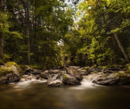
Mont Adstock sits in the Chaudière-Appalaches region of Quebec and has the kind of low-key reputation that tends to attract hikers who prefer discovering a place on their own terms. It's not the most talked-about summit in the province, but that's part of the appeal—the trails are genuine, the forest is thick, and the views from the top are the kind that make the climb feel like it was worth every meter of elevation.
The mountain tops out at 712 meters, and that vertical gain is real: the Summit Trail covers 4.2 km with a full 712-meter elevation gain, which puts it firmly in moderate territory. Budget around 2 hours 30 minutes for the round trip, though that can stretch depending on how long you linger at the top.
What the climb actually feels like
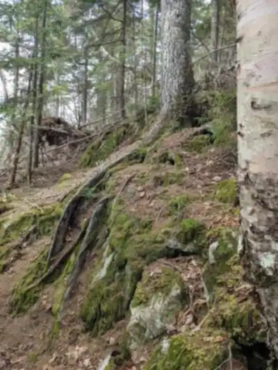
The Summit Trail is the main event at Mont Adstock. From the trailhead, you move into dense forest almost immediately—the kind of mixed woodland that's common in this part of Quebec, where the canopy closes in and the light filters through in patches. The footing shifts as you gain elevation: softer forest floor in the lower sections gives way to rockier terrain as you push higher, so you'll want footwear with decent grip and ankle support.
The grade is consistent enough that you're always aware you're climbing, but it doesn't spike into anything punishing. It's the kind of effort where you find a rhythm and stick with it. The rocky stretches closer to the summit are where the trail gets its character—more exposed, more technical underfoot, and with the first real hints of the view opening up around you. When you finally crest the top, the landscape spreads out in a way that feels genuinely earned: valleys, forested ridges, and on clear days, the Appalachian Mountains stretching out toward the horizon.
The summit view
The panoramic view from the top is the defining feature of a trip to Mont Adstock. You're looking out over layered terrain—nearby slopes covered in trees rolling down into broader valleys, with the Appalachian range visible in the distance when the weather cooperates. It's the kind of viewpoint where you naturally slow down, scan the horizon, and take a few more photos than you planned. A clear day here is worth timing your visit around if you have the flexibility.
Other trail options
Not every visit to Mont Adstock needs to be a summit push. The area has shorter, gentler trails that work well for families, newer hikers, or anyone who wants time in the forest without committing to a full climb. These routes keep you in the scenery—moving through wooded sections, watching for wildlife, taking in the environment at a slower pace—without the sustained elevation gain of the summit route.
In winter, the mountain shifts into a different mode entirely. The trail network supports snowshoeing and cross-country skiing, and the forested terrain takes on a quieter character under snow. If you've hiked here in summer, coming back in winter gives you a genuinely different experience of the same landscape.
Wildlife and forest environment
Moving through the woods at Mont Adstock, you're in active habitat. Deer are part of the local wildlife—occasionally spotted near the forest edge or moving quietly through the trees—and various bird species are present throughout the trail network, particularly in the sheltered sections where the forest canopy creates good cover. Even when you don't spot animals directly, the signs are usually there: movement in the brush, birds calling from overhead, the general sense that the forest around you is doing its own thing independent of the trail.
Getting there and nearby services
Mont Adstock is within reasonable driving distance from both Quebec City and Montreal, which makes it a workable day trip or a natural anchor for a weekend in the Chaudière-Appalaches. The nearby town of Thetford Mines covers the practical side of a visit—there are accommodations and dining options at different price points, so whether you're coming for the day or staying overnight, you have a solid base to work from.
If you're planning a day trip focused on the summit, the 2h30 estimated time gives you room to move at a comfortable pace and still spend time at the top before heading back down. If you're staying the night, the mountain is worth pairing with other outdoor activities in the region—the trail network here has enough variety to fill more than one outing, especially if you're mixing summer hiking with a return visit for winter snowshoeing.
Dress in layers: the temperature difference between the trailhead and the exposed summit can be noticeable, and the rocky upper sections of the trail are more exposed to wind than the forested lower half.
Recommended gear for this trail


Ready to go?
Everything you need to know before you goStarting Point
The Mount Adstock trailhead is located in Saint-Georges-de-Beauce, Chaudière-Appalaches. To get there, take the Saint-Georges exit from Highway 73 and follow the signs to Mount Adstock.
When?
How much?
- Hiking shoes Essential
- → Salomon Elixir Tour Mid WP · 203.38 $
- Layered clothing Essential
- Rain jacket Essential
- Trekking poles
- → Black Diamond Trail Ergo Cork · 69.99 $
- Headlamp
- → Petzl Actik Core 625 · 103.95 $
FAQ - Frequently asked questions
Everything you need to knowThe Essential Hiking Checklist
Everything you need for your next hike. Bilingual, printable, 1 page.
Download the free checklistSimilar hikes nearby
Discover other trails you might enjoy

Auberge des Glacis
Chaudière-Appalaches
Parc régional du Massif du Sud
Chaudière-Appalaches
Parc Des Chutes-de-la-chaudière
Chaudière-Appalaches

Domaine Joly-De Lotbinière
Chaudière-Appalaches

Domaine du Radar
Chaudière-Appalaches

Mont Chocolat
Chaudière-Appalaches
Hiking near Quebec City
40 trails to explore ~87 km away
We work hard to provide the most up-to-date and error-free data possible. If something seems incorrect, let us know! Your contribution helps the whole community.
Hikers' opinions