

Ready to explore Mont Orignal? Here's everything you need to know before you go!
Discover the trail


Available trails
| Trails | Distance | Elevation | Duration | Difficulty | GPX |
|---|---|---|---|---|---|
| 11.66 km | 896 m | 4h | GPX |
Trail description
Description
Mont Orignal sits in the Chaudière-Appalaches region of Quebec, offering a hiking experience that feels genuinely rewarding without the crowds you'd find at more heavily marketed destinations. The main trail covers 6 kilometers with 610 meters of elevation gain — enough to give you a real workout while staying accessible to hikers with moderate fitness. Plan on about 3 hours for the full route, though you'll likely want to build in extra time at the viewpoints.
What makes this mountain work well is the variety packed into a relatively compact distance. You're not grinding up a single relentless slope — the trail moves through distinct terrain types, follows water features through the lower sections, and opens up progressively as you gain elevation. The experience changes character as you climb, which keeps things interesting from the first steps to the final push toward the summit.
What to expect on the trail
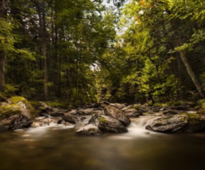
The lower sections of Mont Orignal are defined by dense forest and the sound of streams threading through the trees. The canopy stays thick here, filtering light and keeping temperatures cooler than you'd expect on a summer day. These stream corridors are worth slowing down for — they create natural rest spots and add a calm, immersive quality to the early part of the hike.
As you gain elevation, the forest character shifts. The trees thin out in places, giving you glimpses of the surrounding landscape before you reach the more open sections higher up. The transition from forest walking to steeper climbing happens gradually, so the 610-meter elevation gain doesn't feel like it hits all at once. The trail marking is clear throughout, which means you can keep your attention on the terrain and your surroundings rather than second-guessing your route.
Wildlife is present throughout the mountain rather than concentrated in specific zones. Stay observant and you'll notice signs of animal activity — movement in the understory, bird calls shifting as you move between habitat types, the general sense that the forest is occupied by more than just hikers.
Summit views and scenic payoffs
The panoramic views from the upper elevations of Mont Orignal are the main event, and they deliver. When the trail breaks out of the trees and the landscape opens up, you get a broad look at the rolling terrain of Chaudière-Appalaches stretching out below. The views feel earned after the steady climb, and they're substantial enough to justify sitting down and taking them in properly before heading back down.
One practical note: the scenic payoff isn't reserved exclusively for the summit. The views improve incrementally as you gain height, so even if you turn around before reaching the highest points, you'll still get meaningful panoramic moments along the way. This makes the trail work well for hikers who want to calibrate their effort based on how they're feeling on the day.
Forest and water features
The streams that run through the lower sections of Mont Orignal are a consistent presence rather than a single highlight. They provide both sound and scenery, and the forest around them tends to feel particularly lush and cool. These sections are especially appealing during warmer months when the shade and moving water make the early part of the climb genuinely pleasant rather than just a means to an end.
The forest itself changes as you move through different elevations. Some sections have that tall-canopy, cathedral quality where the light comes through in long shafts. Others open up and feel airier, with more sky visible and a different kind of walking energy. The transitions are gradual enough that you notice them without feeling like you've been dropped into a completely different environment.
Winter use and seasonal versatility
Mont Orignal operates as a ski and snowboard destination in winter, which changes the mountain's character entirely. The winter facilities accommodate different ability levels, making it accessible for beginners and comfortable for more experienced riders. This seasonal range means the mountain is worth considering as a place you return to across different times of year — summer and fall hiking, then winter snow sports when the landscape shifts.
The infrastructure that supports winter operations — lodges, maintained facilities — also benefits summer visitors. The lodges provide real shelter options, and the picnic areas are well-placed for breaking up a longer hike. These aren't afterthoughts; they're practical elements that make the mountain work for groups and families as well as solo hikers.
Planning your visit
The moderate difficulty rating reflects the combination of distance and elevation gain — 6 kilometers and 610 meters is a genuine workout, but it's well within reach for hikers who are reasonably active. The trail variety means you can adjust your ambition based on your group's energy: push to the summit for the full panoramic experience, or focus on the forest and stream sections in the lower elevations for a more relaxed outing.
For families, the lower sections offer plenty of natural interest without requiring the full summit push. The picnic areas give you built-in break points, and the stream sections tend to hold attention well for younger hikers. The trail marking keeps navigation simple, which reduces the mental load when you're managing a group moving at different speeds.
In the broader context of hiking in Chaudière-Appalaches, Mont Orignal stands out for combining a legitimate elevation challenge with trail variety and solid facilities — all without the crowded feel that follows more heavily promoted Quebec hiking destinations.
Services and amenities
This information may vary by season.
Recommended gear for this trail


Ready to go?
Everything you need to know before you goStarting Point
From Quebec City, take Highway 73 south to the Saint-Joseph/Lac-Etchemin exit.
Then take route 276 east and continue to the end. At the junction of route 277, turn left, then immediately left after the bridge, onto rang du Mont-Orignal.
The reception is about 3 km away.
When?
How much?
- Hiking shoes Essential
- → Salomon Elixir Tour Mid WP · 203.38 $
- Layered clothing Essential
- Rain jacket Essential
- Trekking poles
- → Black Diamond Trail Ergo Cork · 69.99 $
- Headlamp
- → Petzl Actik Core 625 · 103.95 $
FAQ - Frequently asked questions
Everything you need to knowThe Essential Hiking Checklist
Everything you need for your next hike. Bilingual, printable, 1 page.
Download the free checklistSimilar hikes nearby
Discover other trails you might enjoy

Auberge des Glacis
Chaudière-Appalaches
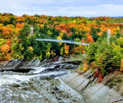
Parc régional du Massif du Sud
Chaudière-Appalaches
Parc Des Chutes-de-la-chaudière
Chaudière-Appalaches

Domaine Joly-De Lotbinière
Chaudière-Appalaches

Domaine du Radar
Chaudière-Appalaches

Mont Chocolat
Chaudière-Appalaches
Hiking near Quebec City
40 trails to explore ~66 km away
We work hard to provide the most up-to-date and error-free data possible. If something seems incorrect, let us know! Your contribution helps the whole community.
Hikers' opinions