

Ready to explore Saint-malachie? Here's everything you need to know before you go!
Discover the trail
Trail description
Description
Saint-Malachie sits quietly in Quebec's Chaudière-Appalaches region, offering hikers a genuine escape into landscapes that feel unhurried and genuinely off the beaten path. This isn't a destination that competes for attention with flashier spots—it earns its reputation through a trail network that rewards those willing to slow down and pay attention to what's around them.
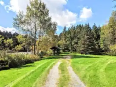
The hiking here covers 27.3 kilometers of interconnected trails with a modest 200 meters of elevation gain, earning an easy difficulty rating that makes it accessible to hikers of all experience levels. With an estimated 7 hours and 15 minutes to cover the full network, this is a destination worth dedicating a full day to rather than rushing through.
Trail Network and Terrain
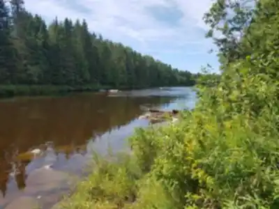
The trail system moves through several distinct environments that keep the experience varied across the full distance. Dense hardwood and coniferous forests make up much of the route, where the canopy filters light into shifting patterns on the forest floor. These sections have a meditative quality—soft underfoot, relatively quiet, with the sound of moving water often audible before you reach it.
The trails follow natural contours alongside rivers and streams, and these waterside stretches tend to be where people slow down the most. Early morning hikers often find mist rising off the water, and the combination of sound and movement makes these sections feel alive in a way that purely forested trails don't. The gentle hills provide enough variation to keep your legs engaged without demanding anything technical or strenuous.
Parc des Chutes Rouillard
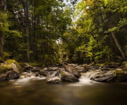
The standout feature of hiking in Saint-Malachie is Parc des Chutes Rouillard, where a series of waterfalls anchor the trail network and give hikers a clear destination to work toward. The falls announce themselves before you see them—the sound carries through the trees and builds as you approach, which is one of those small trail pleasures that never really gets old.
The character of the falls shifts noticeably with the seasons. Spring snowmelt pushes serious volume through the cascades, while late summer and fall reveal the underlying rock formations more clearly and let you appreciate the surrounding vegetation without the noise and spray. The air around the falls runs cooler and more humid than the rest of the trail, and the plant communities here reflect that—mosses, ferns, and moisture-loving species that you won't find in the drier forest sections.
Wildlife and Natural Features
The varied terrain across Saint-Malachie's trail network supports a range of wildlife that makes each outing feel like something more than just a walk. White-tailed deer are a regular presence, particularly in the early morning hours when they move through clearings and along forest edges. The trails are quiet enough that patient hikers often get close before the deer take notice.
Bird life is strong here, with species that shift through the seasons. Spring and summer bring active songbirds throughout the forest, and the proximity to water means loons are part of the soundscape when conditions are right. The diversity of habitats—forest, waterway, open clearings—creates good conditions for birdwatchers and wildlife photographers who are willing to move slowly and wait.
The botanical variety adds its own layer of interest. Ferns and mosses cluster in the wet zones near streams and the falls, while wildflowers push through in forest clearings during spring and early summer. None of this is dramatic, but it gives the trails a texture that changes noticeably as you move between environments.
Seasonal Considerations
Spring brings the waterfalls to their most powerful state as snowmelt feeds the streams, and the emerging leaf canopy creates that particular shade of green that only lasts a few weeks each year. Summer fills the forest out completely and offers the most comfortable conditions for covering the full 27.3 kilometers.
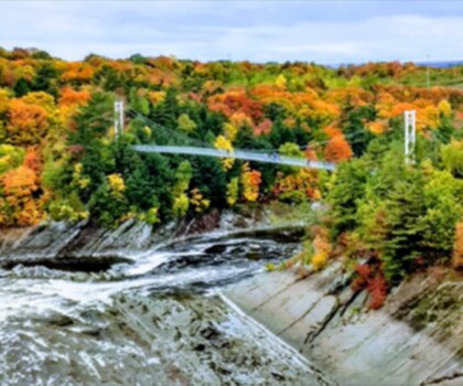
Fall is arguably the strongest season here. The hardwood forests turn through their full range of color, and the combination of autumn foliage and moving water around the falls produces some genuinely striking scenery. Saint-Malachie draws fewer crowds than the more prominent fall foliage destinations in Quebec, which means you get the color without the congestion. Winter changes the access conditions significantly, and hikers should check trail status before heading out in the colder months.
The Town and Local Character
Saint-Malachie the town adds something to the overall experience that purely wilderness destinations can't offer. After a full day on the trails, the local cafes and restaurants give you a place to sit down, eat something made from regional ingredients, and decompress before the drive home. The community has a genuine relationship with the land around it, and locals are typically happy to share current trail conditions or point you toward spots worth exploring.
That kind of local knowledge is worth seeking out, especially if you're planning multiple days in the area or want to make the most of a single visit. Saint-Malachie doesn't have the infrastructure of a major outdoor tourism hub, and that's largely what makes it worth the trip.
Recommended gear for this trail


Ready to go?
Everything you need to know before you goStarting Point
To access the hiking trails, you can start at the main trailhead located at 105 Rang Saint-Charles, Saint-Malachie, QC G0R 3N0. There are no additional trailheads for this location.
When?
How much?
- Hiking shoes Essential
- → Salomon Elixir Tour Mid WP · 203.38 $
- Layered clothing Essential
- Rain jacket Essential
- Trekking poles
- → Black Diamond Trail Ergo Cork · 69.99 $
- Headlamp
- → Petzl Actik Core 625 · 103.95 $
FAQ - Frequently asked questions
Everything you need to knowThe Essential Hiking Checklist
Everything you need for your next hike. Bilingual, printable, 1 page.
Download the free checklistSimilar hikes nearby
Discover other trails you might enjoy

Auberge des Glacis
Chaudière-Appalaches
Parc régional du Massif du Sud
Chaudière-Appalaches
Parc Des Chutes-de-la-chaudière
Chaudière-Appalaches

Domaine Joly-De Lotbinière
Chaudière-Appalaches

Domaine du Radar
Chaudière-Appalaches

Zec JARO
Chaudière-Appalaches
Hiking near Quebec City
40 trails to explore ~46 km away
We work hard to provide the most up-to-date and error-free data possible. If something seems incorrect, let us know! Your contribution helps the whole community.
Hikers' opinions