

Ready to explore Parc naturel régional et Géoparc des Causses du Quercy? Here's everything you need to know before you go!
Discover the trail
Oh no! We don't have any photos 😢
This trail hasn't been captured yet. Be the first to share your adventure!Trail description
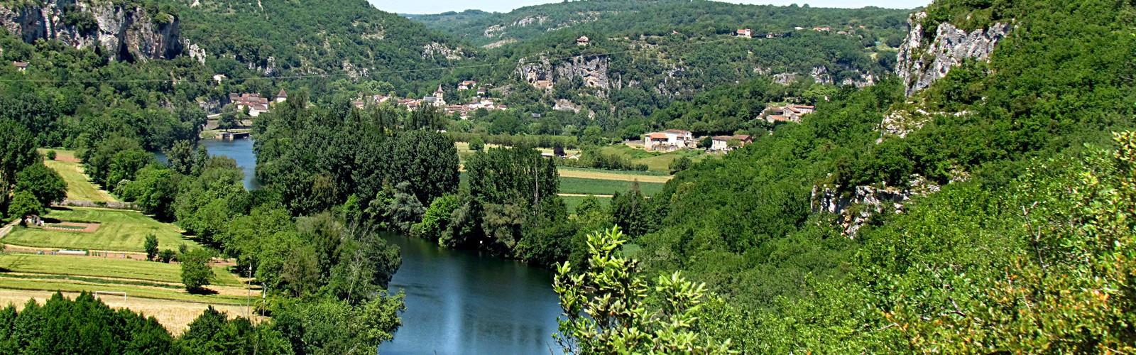
The Causses du Quercy Regional Nature Park and Geopark extends over a fascinating area near Cahors, in Occitanie, where geology tells a story millions of years old. This park is distinguished by its exceptional karst landscapes, sculpted by water in the limestone rock over time. Here you will discover a unique underground and surface world, made up of limestone plateaus cut by deep valleys, punctuated by spectacular caves and striking rock formations.
Hiking on the marked trails, you will cross varied ecosystems where forests of centuries-old oaks alternate with flowering meadows. The karst relief creates particular microclimates that favour remarkable biodiversity. Wild orchids colour the undergrowth in spring, while junipers punctuate the plateaus with their characteristic silhouette. This mosaic of natural environments offers changing panoramas at every bend in the trail.
The Lot river winds through the park, creating spectacular meanders visible from the high points. Its waters have shaped valleys with steep limestone walls, creating striking contrasts between the arid plateaus and the green valley floors. The impressive rock formations bear witness to intense past geological activity, making this territory a veritable open book on the history of the Earth.
Remarkable fauna and flora
The park shelters diverse wildlife perfectly adapted to karst environments. The eagle owl, a majestic nocturnal bird of prey, nests in the limestone cliffs and its calls echo in the valleys at dusk. The ocellated lizard, the largest lizard in France, takes advantage of the warm stones of the causses to regulate its temperature. With binoculars, you can observe many other species that have made their home in these preserved landscapes.
The park's flora reveals fascinating adaptations to limestone soils and the Mediterranean climate. Wild orchids put on a colourful show in spring, while junipers withstand the sometimes arid conditions of the plateaus. This specialised vegetation creates particular atmospheres depending on the seasons and the environments crossed.
Trails and routes
The park's trails are designed to reveal the diversity of karst landscapes. The loop routes make it possible to discover several points of interest without retracing your steps, thus optimising your exploration. You will walk between dolines, those circular depressions typical of limestone terrain where water seeps toward underground networks, and chasms that punctuate the route like so many windows onto the underground world.
The park's average elevation is around 300 metres, offering moderate elevation gains that make hiking accessible while still providing fine viewpoints. The trails vary in difficulty, from easy routes suited to families to more demanding itineraries for experienced hikers. Full loops can reach 20 kilometres, requiring between 4 and 6 hours of walking depending on your pace and the contemplation stops.
Visiting conditions
Access to the park is entirely open and free, allowing everyone to discover this exceptional natural heritage. This accessibility makes the park an ideal destination for family outings or spontaneous getaways. Some trails are perfectly suited to children thanks to their low elevation gain and good accessibility, allowing the youngest to be introduced to the wonders of karst geology.
Dogs are welcome on the trails but must absolutely be kept on a leash to preserve local wildlife, which is particularly sensitive in these specialised environments. This precaution helps maintain the fragile ecological balance of the causses.
Best period and preparation
The park's generally mild climate, with its hot, dry summers, makes hiking pleasant from spring to fall. The latter season offers a palette of vibrant colours that is particularly photogenic. Avoid periods of strong summer heat for long hikes, favouring early-morning starts.
Equip yourself with sturdy hiking shoes, indispensable on the sometimes slippery limestone terrain. Plan suitable clothing with a waterproof layer, because the weather can change quickly. A cap or hat will protect you from the sun on the open plateaus, while a reusable water bottle is essential, since water points are rare on the causses. Do not forget your binoculars to observe wildlife from a respectful distance.
As for safety, systematically check the weather before departure and inform someone close to you of your planned route. Carry a first-aid kit and a charged phone with GPS, because some areas can be isolated. Scrupulously respect signage and local rules, which are particularly important in this karst environment where some areas can present hidden dangers. The Causses du Quercy Regional Nature Park and Geopark awaits you for a total immersion in one of the most singular landscapes in France.
The Essential Hiking Checklist
Everything you need for your next hike. Bilingual, printable, 1 page.
Get your free hiking checklistRecommended gear for this trail
As an Amazon Associate I earn from qualifying purchases.


Ready to go?
Everything you need to know before you goStarting Point
The trailhead for the Causses du Quercy Regional Nature Park and Geopark is located in Saint-Cirq-Lapopie.
When?
How much?
As an Amazon Associate I earn from qualifying purchases.
Affiliate links — LGPO may earn a commission at no extra cost to you.
- Hiking shoes Essential
- → Salomon Elixir Tour Mid WP · 203.38 $
- Layered clothing Essential
- Rain jacket Essential
- Trekking poles
- → Black Diamond Trail Ergo Cork · 69.99 $
- Headlamp
- → Petzl Actik Core 625 · 103.95 $
FAQ - Frequently asked questions
Everything you need to knowSimilar hikes nearby
Discover other trails you might enjoy
Hiking near Sydney
22 trails to explore ~4713 km away
We work hard to provide the most up-to-date and error-free data possible. If something seems incorrect, let us know! Your contribution helps the whole community.
Hikers' opinions
Be the first to review!
No hiker has shared their experience yet. Share your impressions and help other hikers!