
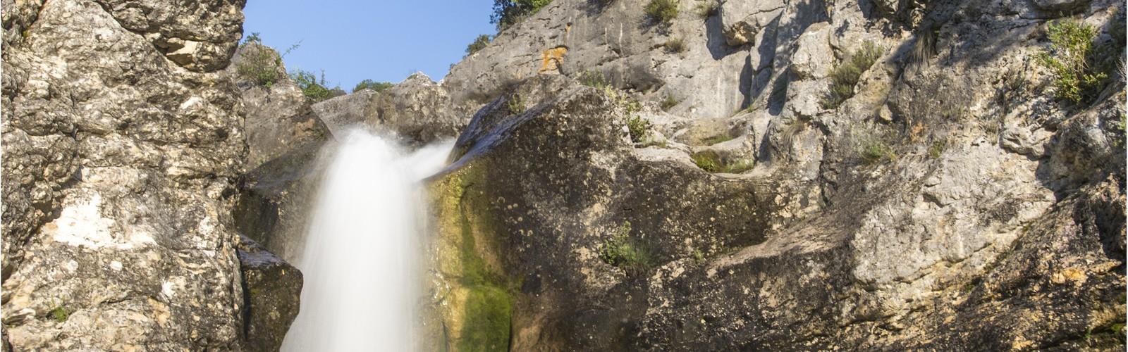

Ready to explore Cascade des petites aiguières? Here's everything you need to know before you go!
Discover the trail
Oh no! We don't have any photos 😢
This trail hasn't been captured yet. Be the first to share your adventure!Trail description
The Cascade des petites aiguières is one of those spots in the Gard that rewards you without asking much in return. At just 2.5 km round trip with 150 meters of elevation gain, it's an easy hike that punches well above its weight in terms of scenery. You're looking at roughly an hour and a half on the trail, which makes it a perfect half-day outing in the heart of Occitanie.
The trail follows a well-established path through mixed deciduous forest, where oaks, beeches, and maples form a canopy that shifts dramatically with the seasons. In spring and summer, the dense green cover keeps things cool and shaded. Come autumn, those same trees turn the whole corridor into a wash of gold and amber. The forest floor stays lush thanks to the humidity generated by the falls themselves, with ferns and mosses coating the rocks and root systems along the way.
The Waterfall System
The cascade is the main event, and it delivers. The site features three primary waterfalls arranged in a stepped formation down the rocky terrain, with smaller falls and rapids filling in the gaps between them. The result is a continuous soundscape of moving water that follows you through most of the hike.
The first and largest waterfall drops approximately 20 meters down weathered limestone faces. You'll hear it before you see it. At the base, the force of the water has carved out deep pools, and the surrounding rock faces are draped in vegetation that thrives in the constant mist. It's the kind of spot where you naturally slow down and stay a while.
The second waterfall, at roughly 10 meters, spreads across a wider section of rock face in a more open cascade. The way the water fans out over the stone creates interesting patterns, and the angle of light here tends to work well for photos. The third fall, around 5 meters, is the most delicate of the three — more of a curtain than a plunge — before the water continues downstream.
Between the main drops, smaller cascades and fast-moving sections keep the energy of the place alive. The limestone throughout the site shows the long-term work of the water: smooth channels, polished surfaces, and undercut edges that speak to centuries of erosion.
Terrain and Trail Experience
The approach is gentle and well-marked, following the river on relatively flat ground for most of the distance. The elevation gain is gradual, with the steeper sections concentrated near the falls themselves. That's also where the footing gets more technical — wet rock near active waterfalls requires attention, especially after rain or when mist is heavy. Sturdy footwear is worth it here even though the overall difficulty is rated easy.
A bridge crossing over the river serves as a key landmark along the route. It's a useful reference point for navigation and offers good views up and down the valley. The crossing also marks the transition into the more protected zone surrounding the falls. For those who want a preview before committing to the hike, the waterfall system is visible from departmental road D948, which gives you a sense of the scale from a distance.
Wildlife and Protected Status
The Cascade des petites aiguières sits within a Natura 2000 designated area, managed in part through the Conservatoire du littoral. That protected status has kept the ecosystem intact and supports a solid diversity of bird species that use the site for nesting and as winter refuge. The combination of flowing water, dense forest, and varied elevation creates multiple habitat types within a small area.
The understory vegetation is particularly rich near the water. Ferns and mosses cover much of the rock surface, and the humid microclimate created by the falls supports plant communities you won't find on drier hillsides nearby. This vegetation also plays a practical role in stabilizing the soil and rock faces around the cascade.
The Natura 2000 framework means the site receives ongoing monitoring and coordinated management. Visitors are expected to stay on marked trails and follow Leave No Trace principles — the designation exists precisely because the ecosystem here is worth protecting long-term.
Planning Your Visit
The hike is well-suited to families, beginners, and anyone looking for a short but satisfying outing in the Gard. The 1h30 estimate is realistic at a comfortable pace with stops at each waterfall. Water levels vary with the season — spring typically brings the strongest flow as rainfall and snowmelt feed the system, while summer tends to be lower but more stable. Autumn combines moderate water with the added bonus of fall color in the forest.
Wear shoes with grip, bring water, and if you're visiting after recent rainfall, expect the rocks near the falls to be slick. The trail itself stays manageable in most conditions, but the final approach to the cascade is where conditions matter most.
The Essential Hiking Checklist
Everything you need for your next hike. Bilingual, printable, 1 page.
Get your free hiking checklistRecommended gear for this trail
As an Amazon Associate I earn from qualifying purchases.


Ready to go?
Everything you need to know before you goStarting Point
To get to the trailhead of the Cascade des petites aiguières, you must travel to Saint-Girons in the Occitanie region.
When?
How much?
As an Amazon Associate I earn from qualifying purchases.
Affiliate links — LGPO may earn a commission at no extra cost to you.
- Hiking shoes Essential
- → Salomon Elixir Tour Mid WP · 203.38 $
- Layered clothing Essential
- Rain jacket Essential
- Trekking poles
- → Black Diamond Trail Ergo Cork · 69.99 $
- Headlamp
- → Petzl Actik Core 625 · 103.95 $
FAQ - Frequently asked questions
Everything you need to knowSimilar hikes nearby
Discover other trails you might enjoy
Hiking near Sydney
22 trails to explore ~4929 km away
We work hard to provide the most up-to-date and error-free data possible. If something seems incorrect, let us know! Your contribution helps the whole community.
Hikers' opinions
Be the first to review!
No hiker has shared their experience yet. Share your impressions and help other hikers!