

Ready to explore Les Cascades d'Arifat? Here's everything you need to know before you go!
Discover the trail
Trail description
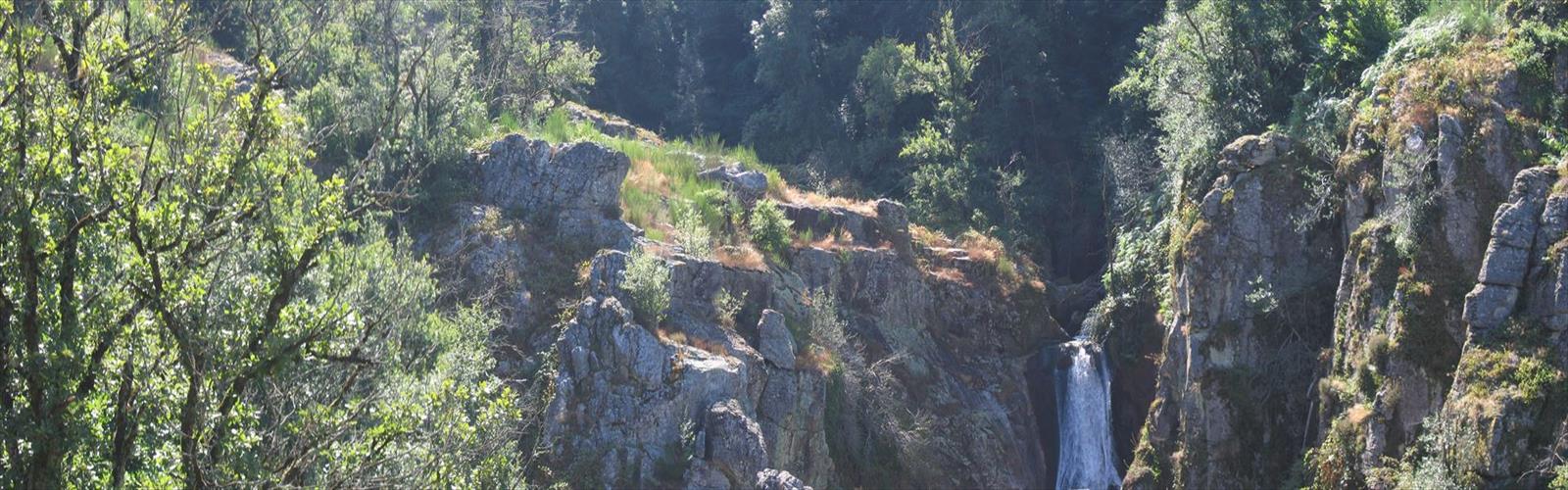
Les Cascades d'Arifat deliver one of the Tarn's most satisfying waterfall hikes — close enough to the falls to feel the spray, short enough to fit into a half-day, and varied enough in terrain to keep things interesting from start to finish. At 6 km with 150 meters of elevation gain and an estimated time of about 1h15, this easy route punches well above its weight in terms of scenery.
The trail begins in classic Tarn countryside, where dry stone walls divide small fields and Mediterranean scrub clings to rocky outcrops. That familiar landscape doesn't last long. Within the first stretch, the path starts pulling you toward a narrow gorge where limestone cliffs rise on both sides and the sound of moving water starts to build. By the time you reach the main cascade — a single drop of roughly 30 meters — the contrast with the open terrain above feels almost theatrical.
What makes Les Cascades d'Arifat stand out among waterfall hikes in the region is the access. You're not looking at the falls from a railed overlook or a distant viewpoint. The trail brings you right into the gorge, close enough that the spray reaches you and the echo of water against stone fills the whole canyon. The rock below the main drop has been carved into a series of natural pools over time, and the layered limestone walls around them show clear geological stratification — a visible record of the ancient seabed this landscape once was.
Trail Terrain and What to Expect
The first section of the hike is the most straightforward. You're moving through oak and chestnut forest on packed earth with occasional stone steps — easy going that lets you settle into a rhythm before things get more technical. The forest here is typical of the Tarn's mid-elevation zones, shaded and relatively cool even in summer.
As the trail drops toward the gorge, the footing changes. The path becomes rockier, the switchbacks tighten, and you start navigating terrain that asks for a bit more attention. The vegetation shifts too — ferns and mosses replace the drier forest understory, and the air gets noticeably more humid as you get closer to the falls. The final approach to the main viewing area involves some light scrambling over water-polished limestone. It's not technically demanding, but the rock can be genuinely slippery when wet, and the combination of mist from the falls and morning dew means you shouldn't assume dry conditions even on a clear day.
Because the route descends into the gorge on the way out, most of the climbing happens on the return. That's worth keeping in mind — your legs will already have done some work on the rocky terrain near the falls before you face the uphill back to the trailhead. Nothing strenuous, but it's a different kind of effort than the descent.
Footwear and Gear
This is not a trail where running shoes or casual sneakers are a good idea. The combination of rocky terrain, wet limestone near the falls, and some light scrambling makes shoes or boots with solid traction and ankle support the right call. Hiking poles are genuinely useful here, particularly on the descent into the gorge and the climb back out.
If you're bringing a camera, keep in mind that the spray zone near the main cascade can reach farther than expected, especially when water levels are high. The lighting in the gorge also presents real contrast challenges — bright at the rim, deeply shadowed at the bottom — so plan accordingly.
Seasonal Conditions
Spring, from March through May, brings the highest water volumes as seasonal rainfall combines to push the falls to their most dramatic. The surrounding vegetation is in full new growth, and the overall experience is at its most impressive. Trail conditions are more demanding during this period, with increased moisture and muddy sections on the upper trail.
Summer offers the most stable conditions underfoot. Water levels are lower than spring peaks, but the falls still run well, and the gorge's microclimate provides real relief from the heat that settles over the Tarn in July and August. It's the most comfortable season for the hike itself, even if the spectacle is slightly reduced.
Autumn brings another surge in water flow as regional rains return, along with strong foliage color in the deciduous forest sections above the gorge. The contrast between golden leaves and white limestone makes this one of the better seasons for photography along the upper trail.
Winter hiking is possible during mild stretches, but ice formation on rocks near the falls creates real hazard. Reduced daylight also means timing matters more than in other seasons.
Wildlife and Natural Features
The habitat variety along the route supports a solid range of wildlife. Dippers are commonly spotted working the fast-moving water near the falls — they're hard to miss once you know what to look for. Birds of prey hunt from the cliff faces above the gorge. The forested upper sections provide cover for wild boar and deer, though early morning or evening hours give you the best odds of an encounter.
The geological interest extends beyond the waterfalls. The limestone throughout the gorge displays classic karst features — solution holes, small cave formations, and erosion patterns that reward a closer look. Botanically, the area sits at a transition zone between Mediterranean and mountain plant communities, which creates more species diversity than you'd typically expect in a relatively compact area.
Getting There and Practical Notes
The trailhead is reached via narrow country roads typical of rural Tarn. Roadside parking near the trail entrance is limited — space for roughly a dozen vehicles — so arriving early is the right move on weekends and during peak seasons. If the main area is full, overflow parking means additional walking along the road before you even start the trail.
There are no facilities at the trailhead or anywhere along the route. Bring enough water and food for the full outing, and plan to stop in the nearest village before heading out if you need anything. The closest services are several kilometers away by road.
The 6 km distance and 150 meters of elevation gain put this firmly in easy territory for most hikers, but the rocky terrain near the falls and the wet conditions in the gorge mean it rewards preparation over casualness — the right footwear and a bit of attention to footing will make the difference between a great outing and an uncomfortable one.
The Essential Hiking Checklist
Everything you need for your next hike. Bilingual, printable, 1 page.
Get your free hiking checklistRecommended gear for this trail
As an Amazon Associate I earn from qualifying purchases.


Ready to go?
Everything you need to know before you goWhen?
How much?
As an Amazon Associate I earn from qualifying purchases.
Affiliate links — LGPO may earn a commission at no extra cost to you.
- Hiking shoes Essential
- → Salomon Elixir Tour Mid WP · 203.38 $
- Layered clothing Essential
- Rain jacket Essential
- Trekking poles
- → Black Diamond Trail Ergo Cork · 69.99 $
- Headlamp
- → Petzl Actik Core 625 · 103.95 $
FAQ - Frequently asked questions
Everything you need to knowSimilar hikes nearby
Discover other trails you might enjoy

Hiking near Sydney
22 trails to explore ~4810 km away
We work hard to provide the most up-to-date and error-free data possible. If something seems incorrect, let us know! Your contribution helps the whole community.
Hikers' opinions
Be the first to review!
No hiker has shared their experience yet. Share your impressions and help other hikers!