

Ready to explore Mount O-J-I, Maine? Here's everything you need to know before you go!
Discover the trail
Trail description
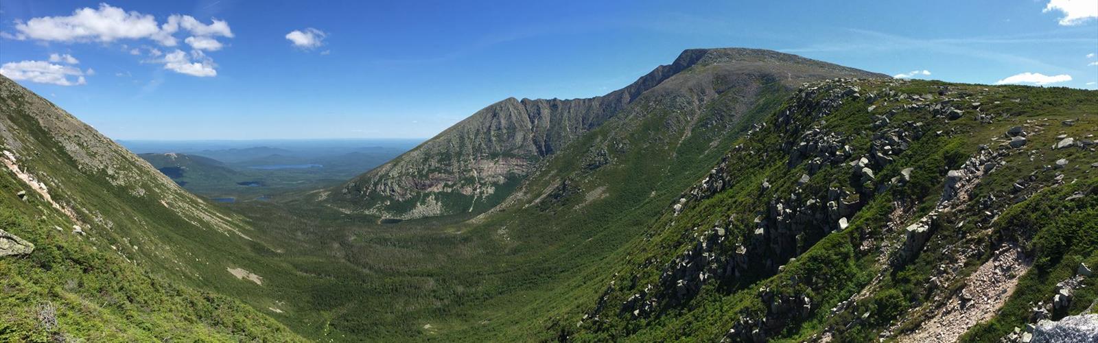
Mount O-J-I is one of Baxter State Park's more distinctive peaks, known for its three-summit layout that gives the mountain its name — the letters O, J, and I tracing the silhouette of the ridgeline when viewed from a distance. It's a satisfying hike that packs real variety into a relatively compact outing, with changing terrain, solid elevation gain, and views that reward the effort.
Trail Experience and Terrain
The hike covers 3.2 km with 1,047 meters of elevation gain — numbers that tell you right away this is a steep, punchy climb rather than a long grind. The trail wastes little time gaining elevation, moving quickly from the forested lower slopes into rockier, more exposed terrain as you approach the upper ridgeline.
The lower section travels through mixed boreal forest typical of Maine's interior — spruce, fir, and hardwood creating a dense canopy that keeps things cool and shaded early in the climb. Trail markings are clear throughout, which matters more as the terrain opens up and the path becomes less obvious underfoot. The upper sections demand careful footing on exposed rock, and while the route stays well-defined, this is the kind of terrain where you want to pay attention to where you're stepping rather than just following the person ahead of you.
Estimated at around 2 hours 30 minutes, the hike moves at a brisk pace given the elevation packed into that distance. Build in extra time if you plan to linger at more than one summit — the three peaks each offer a slightly different angle on the surrounding landscape, and it's worth taking a few minutes at each one rather than rushing through.
The Three Summits
What sets Mount O-J-I apart from a standard out-and-back peak is the opportunity to tag three distinct high points in a single outing. Each summit has its own character — the views shift as you move along the ridgeline, and the sense of progression keeps the hike engaging from start to finish. On a clear day, the sightlines extend across Baxter State Park's vast forested interior, with Katahdin dominating the skyline and the surrounding peaks filling in the backdrop.
These are among the better viewpoints in this section of the park, and the relatively compact trail distance means you're spending more time on top and less time grinding through the approach. Bring a camera — the combination of exposed rock, open sky, and the scale of the wilderness below makes for compelling photography at any of the three summits.
Wildlife and Natural Setting
Baxter State Park is genuine wilderness, and Mount O-J-I sits well within that character. Moose are a real possibility, particularly in the lower forested sections and near any water along the trail. White-tailed deer move through the area regularly, and the varied habitats — from dense forest at the base to open rocky terrain near the summits — support a range of bird species throughout the climb.
Early morning starts give you the best shot at wildlife encounters and also put you on the upper ridgeline before midday heat builds on the exposed rock. The trail sees lighter foot traffic than some of Baxter's more prominent destinations, which adds to the sense of quiet and improves wildlife observation conditions.
Planning Your Visit
Despite being listed as an easy hike, the 1,047-meter elevation gain over 3.2 km is genuinely steep — don't let the difficulty rating lead you to underestimate the physical demand. Sturdy hiking boots with good ankle support are the right call for the rocky upper terrain, and trekking poles are useful on the descent when tired legs meet uneven rock.
Carry enough water for the full 2.5-hour outing plus buffer time, along with snacks or a light lunch if you're planning to spend time at the summits. Temperatures on the exposed upper ridgeline can drop noticeably compared to the trailhead, so pack a wind layer even on days that feel warm at the start.
Check current trail conditions through Baxter State Park before heading out — shoulder season weather in this part of Maine can shift quickly, and the park maintains updated information on trail status that's worth consulting before you commit to the drive in.
The Essential Hiking Checklist
Everything you need for your next hike. Bilingual, printable, 1 page.
Get your free hiking checklistRecommended gear for this trail
As an Amazon Associate I earn from qualifying purchases.


Ready to go?
Everything you need to know before you goStarting Point
To access the hiking trails, head to Baxter State Park in Maine. The primary trailhead is located at the Katahdin Stream Campground. You can reach this area by taking Baxter State Park Road from Millinocket. There are no specific street addresses within the park, but clear signage will guide you to the campground and parking areas.
When?
How much?
As an Amazon Associate I earn from qualifying purchases.
Affiliate links — LGPO may earn a commission at no extra cost to you.
- Hiking shoes Essential
- → Salomon Elixir Tour Mid WP · 203.38 $
- Layered clothing Essential
- Rain jacket Essential
- Trekking poles
- → Black Diamond Trail Ergo Cork · 69.99 $
- Headlamp
- → Petzl Actik Core 625 · 103.95 $
FAQ - Frequently asked questions
Everything you need to knowSimilar hikes nearby
Discover other trails you might enjoy
Chimney Peak, Maine
Maine Highlands
Katahdin
Maine Highlands

Little Spencer Mountain
Maine Highlands
barnard mountain
Maine Highlands
Pleasant Pond Mountain
Maine Highlands
Katahdin Lake
Maine Highlands
Hiking near Bangor
0 trails to explore ~127 km away
We work hard to provide the most up-to-date and error-free data possible. If something seems incorrect, let us know! Your contribution helps the whole community.
Hikers' opinions
Be the first to review!
No hiker has shared their experience yet. Share your impressions and help other hikers!