

Ready to explore Historic Columbia River Highway State Trail? Here's everything you need to know before you go!
Discover the trail
Oh no! We don't have any photos 😢
This trail hasn't been captured yet. Be the first to share your adventure!Trail description
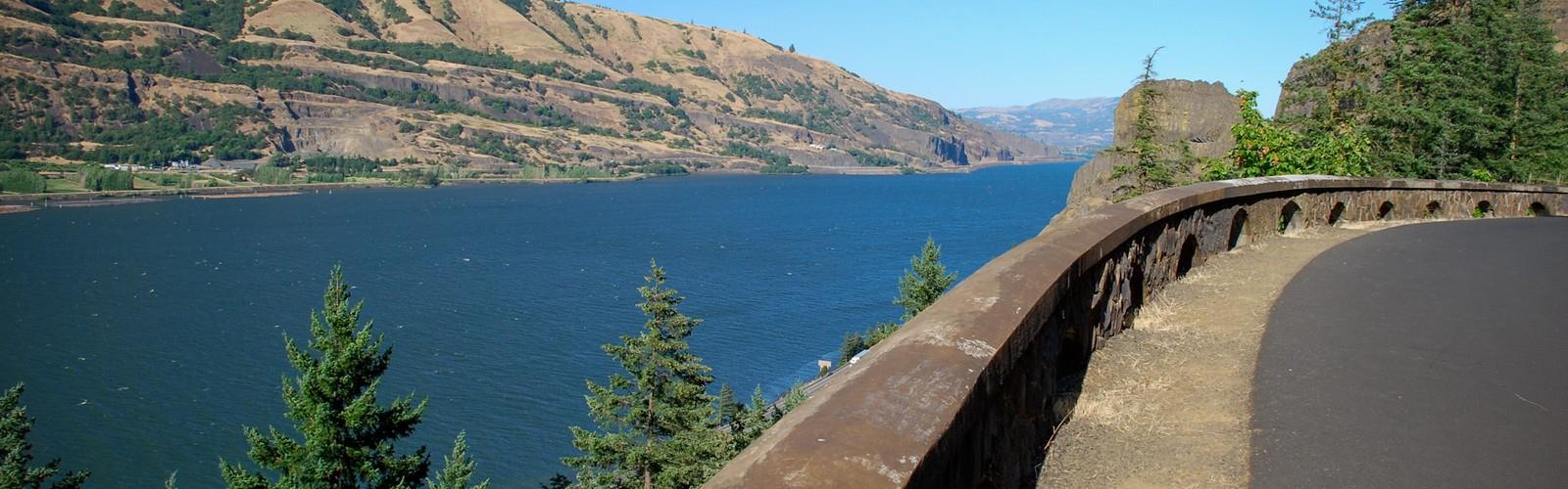
The Historic Columbia River Highway State Trail is one of Oregon's most celebrated multi-use paths, threading through the dramatic Columbia River Gorge along a route that carries more than a century of history beneath your feet. Built originally as America's first scenic highway in the early 1900s, the corridor has been carefully restored and converted into a dedicated trail for hikers, cyclists, and anyone who wants to experience the Gorge at a slower pace. The engineering alone — stone bridges, hand-laid masonry, and tunnels carved through basalt cliffs — makes this trail unlike anything else in the Pacific Northwest.
What Makes This Trail Stand Out
Most trails in the Columbia River Gorge take you up into the hills to earn your views. This one puts you right at the edge of the cliffs, following the original highway alignment that was deliberately designed to showcase the landscape. The builders wanted drivers to feel the scale of the Gorge, and that intention translates perfectly to foot travel. You're walking a route that was engineered for scenery, not efficiency, which means every bend tends to open onto something worth stopping for.
The trail passes through a landscape shaped by both volcanic geology and the catastrophic Missoula Floods that carved the Gorge at the end of the last ice age. Basalt walls rise on one side, and the Columbia River stretches wide below. Depending on which segment you're on, you'll move through mixed forest, open rocky outcrops, and sections where the old highway infrastructure — tunnels, viaducts, and stone guardrails — frames the views like something out of a postcard from 1920.
The Trail Segments
The Historic Columbia River Highway State Trail is not a single continuous path — it exists in several restored segments connected by on-road sections of the original highway. Each segment has its own character and access points, so it's worth knowing which section you're heading to before you go.
- The Mosier Twin Tunnels segment is one of the most popular stretches, running east of Hood River through two tunnels blasted into the basalt in 1921. The tunnels were sealed for decades and reopened after a major restoration effort. Walking through them gives you a real sense of the original highway's ambition.
- The Rowena segment connects to the Rowena Crest viewpoint area, where the highway's famous hairpin curves climb above the eastern Gorge. The landscape here shifts noticeably drier and more open compared to the lush western sections.
- The western segments near Crown Point and the waterfall corridor pass through some of the most iconic scenery in Oregon, with old-growth forest, moss-covered stonework, and proximity to well-known waterfalls along the Historic Highway.
Terrain and Trail Surface
Because the trail follows a converted roadbed, the surface is generally paved or compacted and relatively smooth compared to a typical hiking trail. Grades are moderate — the original highway was engineered with a maximum grade in mind to accommodate early automobiles — which means you won't encounter the steep pitches common on Gorge trails that head straight up the hillside. That said, there is consistent elevation change across most segments, and the exposed cliff-edge sections can feel exposed in high winds.
The paved surface makes this trail accessible to a wider range of users, including families with strollers and people who want a solid footing without scrambling over roots and rocks. It also means the trail is shared with cyclists, so hikers should stay aware of their surroundings, especially on the narrower tunnel sections where passing requires coordination.
Wildlife and Natural Environment
The Columbia River Gorge is a genuine ecological crossroads. The western end sits in a wet, temperate rainforest zone, while the eastern end transitions into high desert. The Historic Columbia River Highway State Trail crosses this gradient, and you can actually feel the shift as you move from one segment to another. Wildflowers are a major draw in spring, particularly on the eastern segments where balsamroot and lupine cover the open slopes. Raptors are commonly spotted riding thermals above the river, and the Gorge is well known among birders for the variety of species that use the river corridor during migration.
Practical Information
Access points vary by segment, and parking areas fill quickly on weekends and during peak wildflower season in spring. Oregon State Parks manages the trail, and a parking pass or day-use fee may be required at certain trailheads — check current requirements before you go, as these details can change seasonally.
- Dogs: Leashed dogs are generally permitted on the trail, but confirm at the specific trailhead you're using, as rules can vary by segment and adjacent park land.
- Bikes: The trail is multi-use and open to cyclists, which is part of its original design intent as a restored transportation corridor.
- Restrooms: Available at major trailheads and day-use areas along the route.
- Cell service: Variable throughout the Gorge — don't count on it in the tunnels or more remote segments.
Tips for Your Visit
Arrive early on weekends, especially in spring and early summer. The Columbia River Gorge is one of the most visited natural areas in Oregon, and the Historic Highway corridor draws significant crowds. Weekday mornings are noticeably quieter. If you're planning to walk multiple segments in a day, consider a car shuttle between trailheads rather than backtracking — the segments are spread out along the Gorge and driving between them is part of the experience.
Weather in the Gorge can shift quickly. The corridor is famous for its strong east winds, and conditions at the rim can be significantly colder and windier than at river level. A packable wind layer is worth bringing regardless of the forecast, and the tunnels stay cool year-round.
The Historic Columbia River Highway State Trail rewards visitors who slow down — the stonework, the views, and the layered history of the place reveal themselves best when you're not rushing to cover distance.
The Essential Hiking Checklist
Everything you need for your next hike. Bilingual, printable, 1 page.
Get your free hiking checklistRecommended gear for this trail
As an Amazon Associate I earn from qualifying purchases.


Ready to go?
Everything you need to know before you goWhen?
How much?
As an Amazon Associate I earn from qualifying purchases.
Affiliate links — LGPO may earn a commission at no extra cost to you.
- Hiking shoes Essential
- → Salomon Elixir Tour Mid WP · 203.38 $
- Layered clothing Essential
- Rain jacket Essential
- Trekking poles
- → Black Diamond Trail Ergo Cork · 69.99 $
- Headlamp
- → Petzl Actik Core 625 · 103.95 $
FAQ - Frequently asked questions
Everything you need to knowSimilar hikes nearby
Discover other trails you might enjoy
Hiking near Victoria
93 trails to explore ~325 km away
We work hard to provide the most up-to-date and error-free data possible. If something seems incorrect, let us know! Your contribution helps the whole community.
Hikers' opinions
Be the first to review!
No hiker has shared their experience yet. Share your impressions and help other hikers!