


Ready to explore Mont Elie? Here's everything you need to know before you go!
Discover the trail
Trail description
Mont Élie sits in the heart of Charlevoix, one of Quebec's most dramatic landscapes, where the land rises sharply from the St. Lawrence and the terrain keeps things interesting at every turn. This is a destination that rewards hikers who want something more than a flat forest walk — the kind of place where the effort feels earned and the surroundings do the talking.
Trail Specifications
Mont Élie offers multiple route options in the Saint-Aimé-des-Lacs area. The main trail is rated as a demanding T3 hike with an elevation gain of approximately 449 meters (1,473 feet) to the 1,034-meter (3,392-foot) summit. Route distances vary from 4.2 to 8.8 miles depending on the loop chosen, with most hikers requiring 4 to 5 hours to complete the ascent and descent. The trail is classified as challenging and demands engagement and proper preparation.
The Terrain
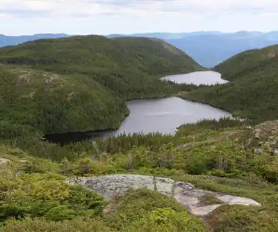
Charlevoix's topography is defined by the ancient Charlevoix impact crater, one of the largest meteorite impact sites in eastern North America, and Mont Élie rises within this geologically rich environment. The landscape here is rugged and varied — mixed boreal forest, exposed ridgelines, and the kind of rocky footing that keeps you paying attention. The vegetation shifts as you gain elevation, with the tree canopy thinning out and giving way to more open terrain higher up.
The forest itself is classic Charlevoix: a mix of conifers and hardwoods that changes character with the seasons. In the warmer months, the understory is dense and green. The trails cut through terrain shaped by glaciation and ancient geological forces, and that history shows in the exposed rock faces and the way the land folds and rises around you.
What to Expect on the Trail
Mont Élie is the kind of hike where the destination matters as much as the journey. The summit — at 1,034 meters — offers views that are genuinely worth the climb. In Charlevoix, the 449-meter elevation gain translates directly into panoramic perspectives over the surrounding valleys, the St. Lawrence corridor, and the layered ridges that define this part of Quebec.
The trail surface varies. Expect a mix of packed earth, roots, and rock as you move through the different elevation zones. Trekking poles are a solid idea, especially on steeper sections where the footing gets technical. Good ankle support in your footwear is worth thinking about before you head out.
This isn't a trail where you can zone out and cruise on autopilot. The terrain demands engagement, which is part of what makes it satisfying. You're moving through a landscape that has real character — not a groomed park path, but actual mountain terrain in one of Quebec's most celebrated natural regions.
Charlevoix as a Hiking Destination
Charlevoix has a well-deserved reputation among Quebec hikers. The region sits within a UNESCO World Biosphere Reserve, and the combination of geological history, biodiversity, and sheer scenic drama makes it stand out even in a province that's full of excellent hiking. Mont Élie fits naturally into that context — it's a trail that reflects what makes Charlevoix worth the drive.
The region attracts hikers from Quebec City and beyond, and for good reason. The proximity to the St. Lawrence, the elevation changes, and the quality of the light in this part of the province make for memorable days on the trail. Mont Élie is one of the options that delivers on that promise.
Planning Your Visit
Before heading out to Mont Élie, it's worth doing a bit of homework on current trail conditions and access. Charlevoix trails can be affected by seasonal conditions — spring snowmelt, fall rain, and winter ice all change the experience significantly. The trail is open year-round, but conditions vary dramatically by season. Checking in with local trail organizations or the relevant land managers before your visit is always a good move.
Plan for a full day outing (4-5 hours hiking time) and bring enough water for the full outing, since there are no guarantees of reliable water sources along the route. Pack layers — Charlevoix weather can shift quickly, especially at elevation, and what starts as a warm morning can turn cool and windy by the time you reach higher ground. A basic first aid kit and a fully charged phone are standard kit for any hike in this region.
- Footwear: Hiking boots with solid ankle support are recommended given the rocky, rooted terrain.
- Trekking poles: Useful on steeper sections, especially on the descent.
- Water: Carry enough for the full hike — don't count on finding water on trail.
- Layers: Weather in Charlevoix changes fast at elevation; pack accordingly.
- Navigation: Download an offline map or bring a paper topo before you lose cell signal.
Getting There
Mont Élie is located near Saint-Aimé-des-Lacs in the Charlevoix region of Quebec, in the Laurentides area. The area is accessible by road, and Charlevoix is a well-traveled destination with established routes from Quebec City and the surrounding area. Confirming the exact trailhead location and parking situation before you go is a smart step — trailhead access details can change, and local sources will have the most current information.
Who This Trail Is For
Mont Élie suits experienced hikers who are comfortable on uneven, natural terrain and who are looking for a genuine mountain experience in Charlevoix. The T3 difficulty rating means this trail is not suitable for casual walkers. If you're used to groomed multi-use paths and want something with more bite — real elevation, real rock, real forest — this is the kind of trail that delivers. It's not the place for a casual stroll, but it's also not so extreme that experienced day hikers need to hesitate.
Experienced families with older kids who have solid trail experience, solo hikers with mountain hiking background, and groups looking for a solid full-day objective in Charlevoix will all find something worthwhile here. The key is going in prepared and with realistic expectations about the terrain and the 4-5 hour time commitment.
Mont Élie is the kind of trail that reminds you why Charlevoix keeps pulling hikers back — the landscape is genuinely compelling, and the effort you put in translates directly into the quality of what you see and experience along the way.
Recommended gear for this trail
As an Amazon Associate I earn from qualifying purchases.


Ready to go?
Everything you need to know before you goWhen?
How much?
As an Amazon Associate I earn from qualifying purchases.
Affiliate links — LGPO may earn a commission at no extra cost to you.
- Hiking shoes Essential
- → Salomon Elixir Tour Mid WP · 203.38 $
- Layered clothing Essential
- Rain jacket Essential
- Trekking poles
- → Black Diamond Trail Ergo Cork · 69.99 $
- Headlamp
- → Petzl Actik Core 625 · 103.95 $
FAQ - Frequently asked questions
Everything you need to know
25 hikes under 2 hours from Montreal
Distance, elevation, parking and season for each one. The ones we go back to ourselves.
Get the guideSimilar hikes nearby
Discover other trails you might enjoy

Mont Du Lac Des Cygnes
Charlevoix

Parc National Des Hautes-gorges-de-la-rivière-malbaie
Charlevoix

Parc National des Grands Jardins
Charlevoix

Mount Morrios
Charlevoix

Sentiers Pédestres Les Éboulements
Charlevoix

Sentier Des Caps De Charlevoix
Charlevoix
Hiking near Quebec City
40 trails to explore ~138 km away
We work hard to provide the most up-to-date and error-free data possible. If something seems incorrect, let us know! Your contribution helps the whole community.
Hikers' opinions
Be the first to review!
No hiker has shared their experience yet. Share your impressions and help other hikers!